

Hurricane Henri moving faster as it targets Northeast for landfall
ORLANDO, Fla. - Hurricane Henri is moving faster as the Category 1 storm makes its way to the northeastern U.S. states. Meanwhile, Grace, now a tropical storm, is weakening rapidly after making a second landfall in Mexico.
HURRICANE HENRI
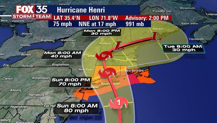
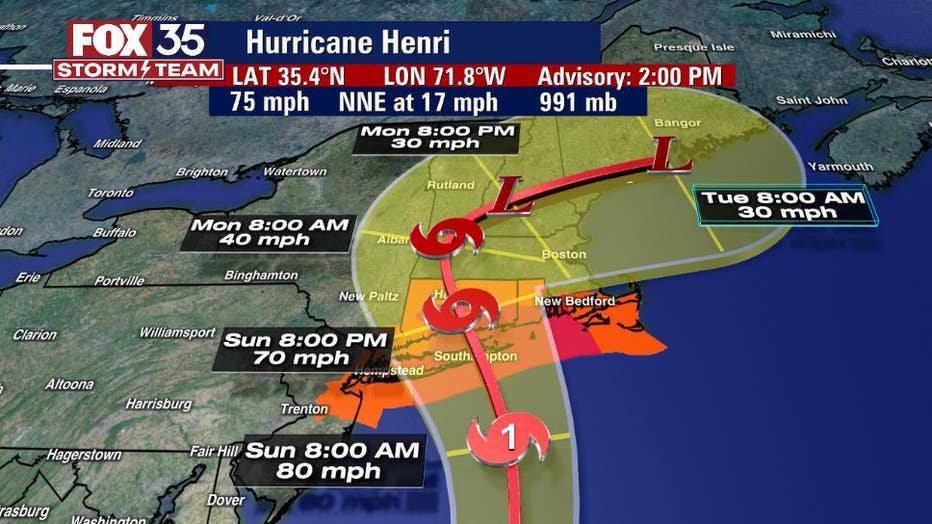
Henri strengthened into a hurricane on Saturday. Dangerous storm surge, hurricane conditions, and flooding rainfall are expected in portions of the northeast United States beginning late tonight or early Sunday.
Maximum sustained winds are at 75 mph.
WEATHER ALERTS: Download the FOX 35 Storm Team Weather app for live radar, severe weather alerts, and daily forecast reports on your phone
"Henri is expected to make landfall on Long Island or in southern New England on Sunday. Strengthening is forecast through tonight. Although some weakening is expected prior to landfall on Sunday, Henri is forecast to be at or near hurricane strength when it reaches the coasts of Long Island and southern New England."
While Florida won't see any direct impacts from Henri, we will see some indirect impacts with dangerous rip currents at area beaches.
TROPICAL STORM GRACE
The National Hurricane Center (NHC) said Saturday that Grace has weakened to a tropical storm with 45 mph winds.
TRACK THE TROPICS: Visit the FOX 35 Storm Team Hurricane Center for the latest tropical weather outlook and more
"The center will move over central and west-centralMexico through tonight. Maximum sustained winds have decreased to near 45 mph with higher gusts. Continued rapid weakening is expected while thesystem moves over the mountains of central and west-central Mexicotoday and tonight, and Grace is forecast to weaken to a tropicaldepression later today and dissipate by early Sunday."
THIRD SYSTEM IN ATLANTIC
A tropical wave near the Cabo Verde Islands has a 20 percent of development over the next 5 days. The FOX 35 Storm Team will be tracking it.
Watch FOX 35 News for the latest updates throughout hurricane season.