

Hurricane Erin nears U.S. coast, to bring life-threatening surf to Florida; NHC tracking 2 other disturbances

Orlando Weather Forecast PM: August 20th, 2025
FOX 35 Storm Team Senior Meteorologist Noah Bergren is tracking significantly higher chances for showers and storms the next few days.
ORLANDO, Fla. - Hurricane Erin continues its northwestward track through the Atlantic, prompting new warnings and raising concerns along the United States East Coast, with dangerous high surf and life-threatening rip currents expected along Florida’s coastline through midweek.
In addition, the National Hurricane Center (NHC) is continuing to track two other tropical waves for possible development.
Here's the latest on everything we know about Hurricane Erin, as well as the other two systems in the tropics.
Hurricane Erin latest updates
What we know:
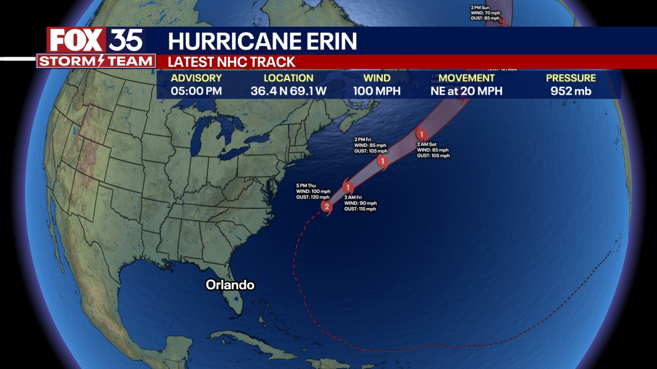
Late Wednesday evening, Erin was located about 200 miles southeast of Cape Hatteras, North Carolina, with maximum sustained winds of 110 mph.
The Category 2 storm is not expected to make landfall in the U.S. but outer bands will brush the North Carolina coast, bringing strong winds, heavy rain and rising surf forecast.
What's next:
Hurricane Erin is expected to move between the U.S. East Coast and Bermuda through early Friday, then pass south of Atlantic Canada on Friday and Saturday.
What is a Tropical Storm Warning, Tropical Storm Watch and a Storm Surge Watch?
Why you should care:
A Tropical Storm Warning means that tropical storm conditions are expected somewhere within the warning area.
A Tropical Storm Watch means that tropical storm conditions are possible within the watch area, generally within 48 hours.
A Storm Surge Watch means there is a possibility of life-threatening inundation from rising water moving inland from the coastline, in the indicated locations during the next 48 hours.
Will Hurricane Erin impact Florida?
Local perspective:
Hurricane Erin's main impact on Florida will be dangerous high surf and life-threatening rip currents along the state's Atlantic coast through the middle of the week, with wave heights potentially reaching 5–10 feet.
While no direct landfall or wind impacts are expected for Florida, the storm's large size will create hazardous beach conditions, and officials are urging caution for swimmers and boaters on the East Coast.
2 tropical waves behind Hurricane Erin
Dig deeper:
Outside of Hurricane Erin in the western Atlantic, the NHC is monitoring two areas of disturbed weather in the Atlantic Ocean, but forecasters say neither appears likely to develop into a tropical cyclone that would immediately threaten any landmasses.
The first disturbance is located several hundred miles east of the Leeward Islands is producing a broad area of disorganized showers and thunderstorms. It has been given a high chance of development over the next several days (70%), but the FOX Forecast Center said that, given its current structure of being spread out, it would take until at least the end of the week to consolidate into a tropical depression or tropical storm.
Even if the feature were to further organize, most computer forecast models suggest it would take a more northward track, potentially impacting the northern Caribbean islands but staying well away from the continental U.S.

Invest 99L has a challenging environment to develop
A second disturbance, designated Invest 99L, even has less of a chance for development (40%).
Located much closer to the coast of Africa than any other landmass, the NHC said the system has only a low chance of development through the next week.
Environmental conditions across much of the Atlantic are expected to become increasingly hostile, with dry air and unfavorable wind shear expected to suppress growth of 99L.
While there is a possibility the disturbance could venture on a more southerly path and find a more favorable environment, conditions are expected to be marginal at best during the next two weeks.
No reliable computer forecast models project the system will organize into a tropical cyclone through the end of the month, but if the disturbance is still around in early September, conditions could become more favorable for tropical cyclone formation.
The next tropical storms that will develop across the Atlantic basin will be named Fernand and Gabrielle.
The Source: This story was written based on information shared by the National Hurricane Center (NHC), FOX Weather and the FOX 35 Storm Team on Aug. 20, 2025.