

Orlando Weather: Warm start to the weekend before cold front moves in
Orlando AM Weather Forecast: Record-Breaking Temps for Central Florida
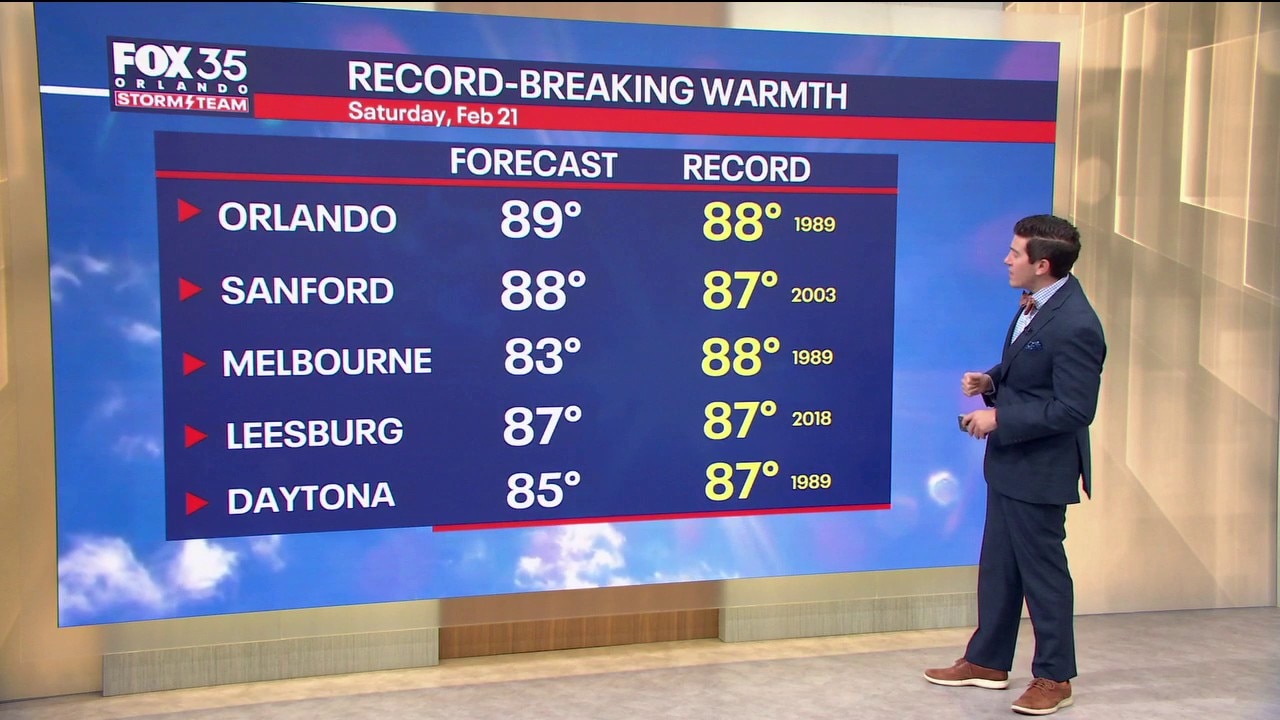
The warmth is our big weather headline as we kick-off the weekend. Meteorologist T.J. Springer lets us know how long it sticks around before our next cold front moves in. A STORM TEAM ALERT has been issued for the cold early next week
ORLANDO, Fla. - A ridge of high pressure is in control and that means more potentially record-breaking temperatures for our Saturday afternoon.
Friday, temperatures rose close to 90°, and we are going to do it again today. Expect highs to rise to around 89° in Orlando with temps near the beaches in the lower to middle 80s.

What will the weather look like tonight?
What to Expect:
It'll be a touch muggier today, but overall, this will still feel like a "dry heat" compared to what we normally feel when it gets this warm. The warmth combines with plenty of sunshine, so be sure you drink lots of water and don't forget the ball cap.
The above-average feels are streaming in ahead of a storm system that looks to inch closer tonight.
That makes for increasing clouds and the chance for a few showers NW of Orlando. Lows will be mild, dipping back into the lower to middle 60s.
What will the weather look like tomorrow?
What to Expect:
This strong cold front starts to swing into Central Florida early Sunday with hit-or-miss showers on the docket.
They'll likely stick around through around lunchtime with the boundary through the region by mid-afternoon. Sunday afternoon will be brighter, breezier, and cooler as the chill starts to settle in.
Highs Sunday afternoon will be seasonably warm, but much cooler than Saturday, topping out in the middle to upper 70s. Clouds started to clear Sunday night with lows tumbling back into upper 30s and lower 40s. Wind chills will feel brutal, around freezing as we hit pre-dawn Monday. Be sure you bundle up if you're heading out.
Looking ahead — Storm Team Alert
What to Expect:
The breeze will still be strong on Monday behind this cold front, making it feel quite wintry to kick off the workweek. We'll see plenty of sunshine, which will at least make it look nice outdoors. Afternoon readings on Monday struggle to make it out of the middle to upper 50s with temps even colder Monday night.
Lows fall back into the lower to middle 30s, which is why we have the STORM TEAM ALERT issue.
Wind chills will be brutal, in the middle to upper 20s. With that chill, we're looking at Freeze Warnings and Cold Weather Advisories likely being issued. Temps Tuesday will still be well below normal, only rising into the upper 50s and lower 60s, but beyond that, conditions improve.
A ridge of high pressure builds in with highs climbing back toward 70 by midweek with highs in the lower 80s by Thursday and Friday. Another disturbance looks to move our way by Friday, which brings a slim chance of a few showers.

The Source: This story was written by FOX 35 storm team meteorologist on February 21, 2026.