

Orlando weather: Hot, dry start to week with limited rain and triple-digit heat

Orlando PM Forecast: June 22, 2025
FOX 35 Storm Team Meteorologist Laurel Blanchard provides the latest forecast for the Central Florida area. Expect a mild and muggy Sunday evening.
ORLANDO, Fla. - Central Florida is in for a hot and mostly dry start to the week, with only isolated rain chances and heat index values soaring into the triple digits.
What will the weather be like tonight?
What to Expect:
Spotty showers and storms stay very scattered through the rest of the evening. Storms will quiet down through the late evening hours, leaving partly cloudy to mainly clear skies tonight.
Overnight, it'll be mainly dry and muggy are on tap with temperatures in the mid 70s.
What will the weather be like on Monday?
What to Expect:
Because of high pressure dominating to our Northwest, it is pushing in drier air, limiting rain chances for the rest of the weekend and cutting the humidity but amping up the heat.
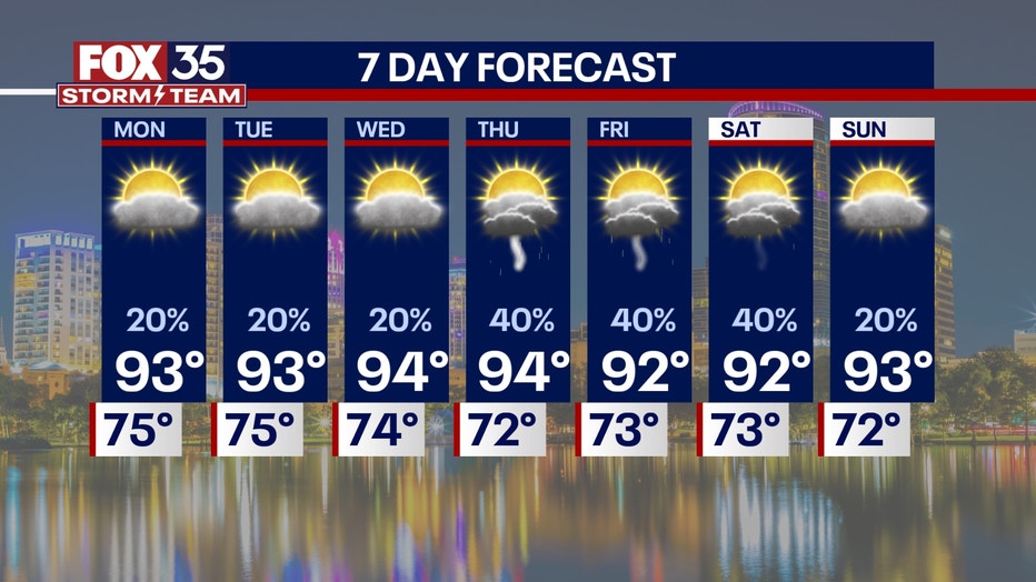
Although the rain chances for the start of the workweek will be limited, they won't be 0. Still expecting some sea breeze showers to pop up, but because of the STRONG high pressure, most of the storms will be pushed towards the Gulf coast.
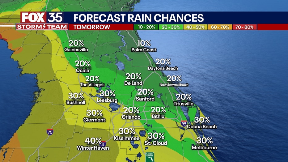
Highs across the region will be in the low to mid 90s with tamps feeling like triple digits.
What will the weather look like the rest of the week?
What to Expect:
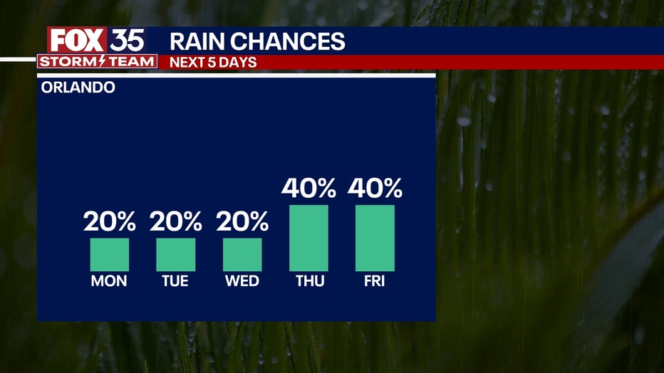
Rain chances stay very spotty looking ahead to midweek.
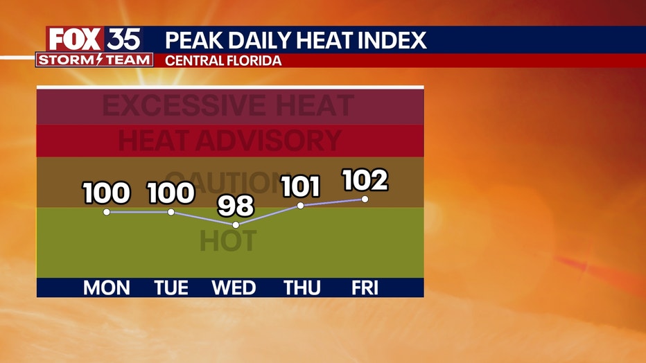
A heat dome will build in across the mid-East coast and this will really turn up the heat. Here in Central Florida, highs will reach the mid 90s next week with heat indices well in the triple digits.
This ridge in the atmosphere starts to breakdown late in the week popping our rain chances up a little more by Thursday and Friday.
What is happening in the tropics currently?
What we know:
As of 2PM Sunday, there is a 20% chance of development in the Central Atlantic. Satellite data indicate that a low pressure system has formed about 450 miles east-southeast of Bermuda.
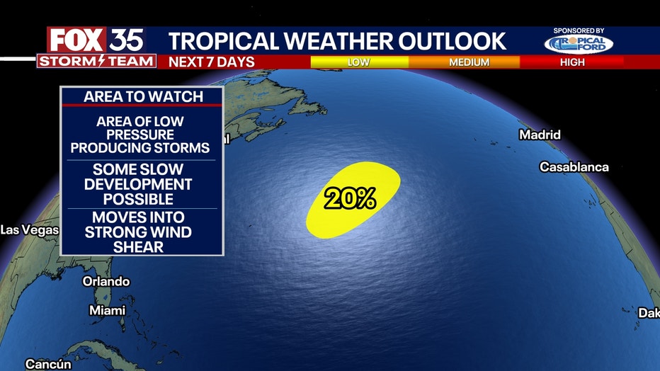
The associated showers and thunderstorms remain disorganized, but some slow development is still possible.
Further development into anything stronger than just an area of interest seems slim because it moves into an area of high wind shear and cooler water... aka not good conditions for tropical development.
FOX 35 Storm Tracker Radar and Live Weather Cameras
Track live when storms move across your area using the FOX 35 Storm Tracker Radar below. You can also watch as heavy rain moves across Central Florida on our Live Weather Cameras' page here.

More radar maps from FOX 35 Storm Tracker Radar
- Brevard County
- Flagler County
- Marion County
- Osceola County
- Orange County
- Polk County
- Seminole County
- Sumter County
- Volusia County
- U.S./National Radar
STAY CONNECTED WITH FOX 35 ORLANDO:
- Download the FOX Local app for breaking news alerts, the latest news headlines
- Download the FOX 35 Storm Team Weather app for weather alerts & radar
- Sign up for FOX 35's daily newsletter for the latest morning headlines
- FOX Local: Stream FOX 35 newscasts, FOX 35 News+, Central Florida Eats on your smart TV
The Source: This story was written based on information shared by the FOX 35 Storm Team on June 21, 2025.