

Orlando weather: Heat and storms continue through the holiday weekend
Orlando AM Weather Forecast: Storm chances hold as we round out holiday weekend
Our Sunday is a wash, rinse, repeat sort of day across Central Florida. Meteorologist T.J. Springer has the timeline of storms and more heat ahead in the 7-Day.
ORLANDO, Fla. - Storms ignited on July 4th during the afternoon, and they lingered through the evening. The latter half of our holiday weekend looks quite similar. We'll start off dry with plenty of sun, but conditions turn unsettled Sunday afternoon and evening.
Temps are going to stay just a touch above normal through the remainder of our holiday weekend. Highs on July 4th spike into the lower to middle 90s and feel like temps sitting in the lower to middle 100s.
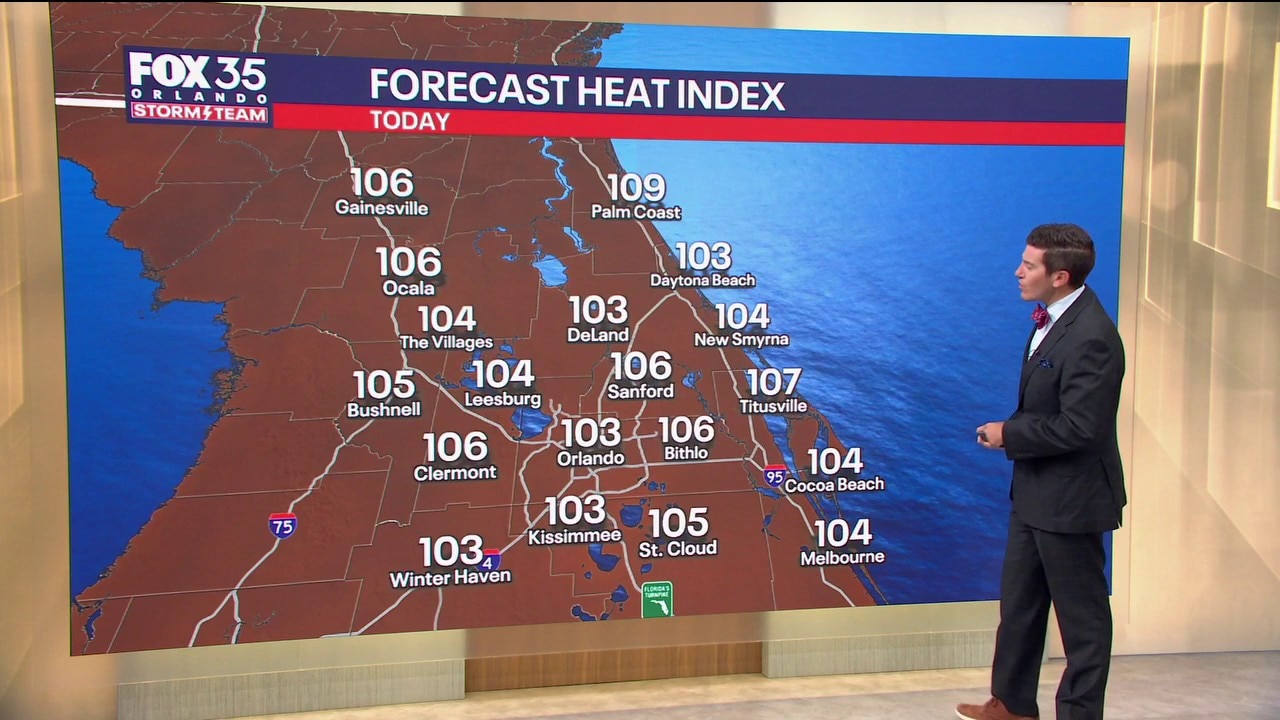
A major heat risk is in play for most of Central Florida, so be sure you're drinking plenty of water.
Highs on Sunday stay in the lower to middle 90s as well. Temperatures actually spike at the end of the workweek as a ridge of high pressure builds back in.
We could be feeling heat indices back into the middle to upper 100s as highs soar into the middle and upper 90s.
Storms stick around on Sunday
Today won't be a washout, but it's essentially a wash-rinse-repeat of Saturday. We'll have lots of moisture in the air to work with and as the sea breeze comes in, storms will spark. Coverage peaks during the afternoon, with rain chances up around 60%.
A couple storms could be on the stronger side with gusty wind, frequent lightning, as well as torrential rain. Through dinnertime on Sunday, storms will start to fade away, with just a few potentially hanging around past sundown.
Looking ahead
What to Expect:

As this ridge of high pressure takes over next week, drier air in the atmosphere will help bring our storm chances a bit. Rain chances as we kick off the workweek come down to around average for this time of year, 40–50%.
By midweek into late week, they're dropping to around 30% with the help of this area of high pressure.
The Source: This story was written based on information provided by Meteorologist T.J. Springer on July 5, 2026.