

Orlando weather: Central Florida to begin drying out after heavy rain hits coastal cities
Orlando Weather Forecast: Oct. 1, 2023
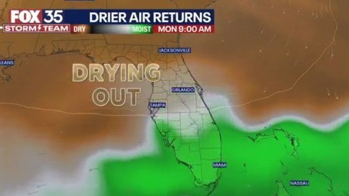
After a wet weekend, Central Florida will begin to see things dry out a bit.
Tonight's low: 75 degrees | Tomorrow's high: 85 degrees
Main weather concerns: Rain is coming to an end this evening across Central Florida. Few showers remain mostly south of Orlando and should continue moving out of our area. After a soggy weekend with a number of areas seeing 2-5" of rain near the coast, we'll have an opportunity to dry out to begin the week. Winds will be breezy with gusts up to 20-25 mph out of the NE. Rain chances should remain low through Tuesday.
Parts of Brevard County saw incredible rain totals this weekend thanks to persistent heavy showers and storms moving onshore. This led to street closures and a number of flood warnings throughout the weekend. Here is a look at some of the higher rain totals from just Sunday:
- Palm Bay - 6.24 inches
- Indiatlantic - 5.98 inches
- Melbourne 5.59 inches
- Rockledge - 7.24 inches
- Titusville - 6.64 inches

The front that has been the culprit of our rainy weather should push south throughout the day and lower rain chances by this evening. Highs will be cooler under cloudy skies with most in the low to mid 80s.

BEACHES:
Conditions will begin to improve along the coast. Surf height is up to 4–6 feet and a high risk of rip current. Winds will be out of the NE and gusty at times. Better conditions could arrive by late afternoon if you at least want to walk along the beaches.
OUTLOOK:
With the front pushed to the south, our weather will quickly improve early this week. Drier air will work its way in and lower rain chances beginning Monday. Expect more sunshine with limited storm chances for much of the week. The best chance of any rain will be along the coast by midweek. Highs return to the mid-80s.

TRACKING THE TROPICS:
Philippe and Rina continue to churn in the Central Atlantic northeast of the Leeward Islands. Rina has been sheared apart and is expected to gradually dissipate. It was downgraded to a tropical depression on Sunday. Philippe remains a tropical storm and is expected to brush the Leeward Islands early this week. The storm is forecast to struggle until later this week when it moves north in the Atlantic. It could become our next hurricane. Outside these two storms, the tropics remain quiet. Keep with the FOX 35 Storm Team for more updates.

Tracking the Tropics: Oct. 1, 2023
The FOX 35 Storm Team is monitoring two tropical systems in the Atlantic Ocean that are being impacted by wind shear. Tropical Storm Philippe is expected to strengthen into a Category 1 hurricane, while what was once Tropical Storm Rina has been downgraded to a tropical depression.