

Florida weather: Orlando bracing for strong storms, damaging wind, heavy rainfall this weekend
Stream FOX 35 News
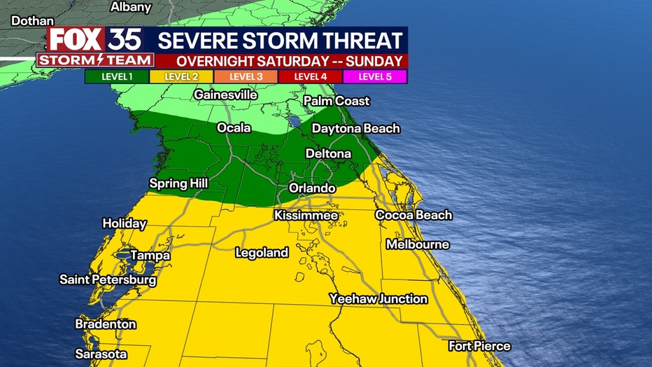
A strong low-pressure storm system is expected to form in the Gulf of Mexico over the weekend and then cross over the Florida Peninsula, bringing the potential for strong thunderstorms with heavy rain, flooding, strong winds, lightning, and the potential for a few tornado warnings from Saturday night into Sunday morning.
Here's what you need to know:
Is there a tropical storm or hurricane coming to Florida?
No, there is not a tropical system, tropical storm, or hurricane headed toward Florida.
What's expected to form in the Gulf of Mexico is a strong low-pressure system, which we're referring to as a "Gulf Low." However, it has the potential to create "tropical storm-like" conditions (keyword: like conditions), which means powerful, gusty winds (35 mph+), heavy rainfall, and high tides along the coasts.
It's also possible that there could be some tornado warnings – and tornadoes – issued in Florida. This will not be a tropical system because it will be "cold-cored" and not "warm-cored" like a tropical cyclone would be. Think of that like a fireplace – a tropical system has a warm core of air and thunderstorms rising in the center. This will not. It will be energized more from the atmosphere high up, than the ocean surface and warmth.
Download the FOX 35 News app and FOX 35 Storm Team Weather apps to receive news and weather alerts.
Timeline: When is this "Gulf Low" expected to hit Florida?
Rain overspreads Florida from south to north during the morning hours on Sunday. After noon, rain should be falling everywhere, and fall at varying intensities through the afternoon and evening. There will be waves of tropical downpours that continue all night. When it rains, it will pour at times. The rain rapidly moves out and ends between 8 a.m. and 11 a.m. on Sunday. A few showers are still possible Sunday afternoon as winds switch to the NW, but nothing heavy or widespread is expected in the evening hours.
Watch below: Orlando Weather Forecast Video

Tropical storm-like conditions this weekend
The FOX 35 Storm Team is monitoring the Gulf of Mexico, where a potent low-pressure system is expected to form and then move across Florida, bringing tropical storm-like conditions.
What are the biggest weather threats? Wind. Rain. Isolated tornadoes.
Strong (non-thunderstorm) winds, heavy rains, coastal flooding and erosion, frequent cloud-to-ground lightning, and the possibility of isolated tornadoes are the biggest threats to Florida from this weather system.
Those living or vacationing along Florida's coasts could see wind gusts of 50 mph or higher – tropical storm strength – while those more inland could see guests of 35-50 mph (also tropical storm strength).
People could see between 2" and 5" of rain beginning Saturday morning and lasting through Sunday. Isolated amounts of 6" or more are possible.
The tornado threat will run from midnight on Sunday to 8 a.m. Sunday, and it is important that you go to bed with your phone on and that you can receive audible weather alerts in case of a tornado in your location. Any storms within that time frame can produce tornadoes in Central Florida.
What is the difference between a tropical storm watch and a tropical storm warning?
A Tropical Storm Watch is issued when a tropical cyclone containing winds of 34 to 63 kt (39 to 73 mph) or higher poses a possible threat, generally within 48 hours. The watch doesn't mean that tropical storm conditions will arise.
A Tropical Storm Warning is issued when sustained winds of 34 to 63 kt (39 to 73 mph) or higher associated with a tropical cyclone are expected in 36 hours or less. These winds may be accompanied by storm surge, coastal flooding, and/or river flooding.