


Brooks Garner
Meteorologist Brooks Garner has been part of FOX 35's Storm Team since June 2021, leading viewers and the newsroom through Florida's major weather events, including severe weather, tornadoes, heatwaves, tropical storms, and hurricanes.
You can watch Brooks on weekday mornings on FOX 35's Good Day Orlando, 4 a.m. - 10 a.m.
Brooks recently went viral after he was on the air tracking severe weather in Central Florida and a tornado passed over the station – all caught on camera. He's also helped lead hurricane coverage for Hurricane Ian, Idalia, Nicole, Helene, and Milton.
He holds dual seals of approval from the American Meteorological Society and the National Weather Association. His weather coverage has earned him an Edward R. Murrow Award, several Emmy Awards, and an AP Award.
Before Orlando, Brooks worked in Boston, Massachusetts; Denver, Colorado; Columbia, South Carolina; Houston, Texas; and Tampa, Florida.
Other career highlights include flying into Hurricane Sandy with NOAA’s Hurricane Hunters and covering Hurricane Harvey’s destruction across Texas and Louisiana, where his station was eventually destroyed by floodwaters.
When he’s not tracking storms, Brooks enjoys spending time with his wife Erica and their children, exploring the natural wonders of Florida.
The latest from Brooks Garner


Orlando weather: Dangerous heat expected across Central Florida as storm chances continue
Hot and steamy temperatures continue this week across Central Florida. Afternoon highs will continue to soar into the mid 90s through the end of the work week. Daily afternoon downpours are likely just about each and every day this week as well.

Orlando weather: Daily thunderstorms expected along I-4 corridor into weekend
Scattered evening thunderstorms remain possible west of Orlando, but most of Central Florida is expected to stay dry.
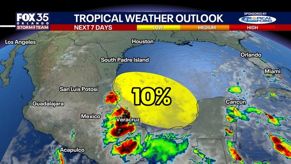

National Hurricane Center flags first area of interest in Gulf, tied to remnants of Tropical Storm Cristina
The Atlantic hurricane season has produced its first tropical outlook area of the year, but the chance for development is low.


Orlando weather: Temps in the 90s for Central Florida before rain chances return midweek
After starting off in the upper 60s and low 70s this morning, temperatures across Central Florida will heat up into the 90s.


Orlando weather: Rare June cooldown settles into Central Florida
A highly unusual June cold front is pushing through Central Florida, dropping afternoon highs into the low 80s and triggering gusty winds up to 35 mph.


Orlando weather: Timeline of storms expected this evening for parts of Central Florida
There is a possible severe storm threat for Orlando and Central Florida on Tuesday night. Here's live forecast updates, weather alerts and warnings, and the storm timeline.
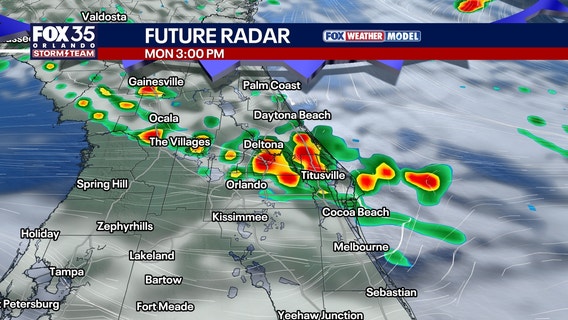

Orlando weather: More storms expected across Central Florida
Scattered storms will develop along a cold front. Rain will be likely from Ocala to Titusville, but chances drop off as you get south of Orlando.
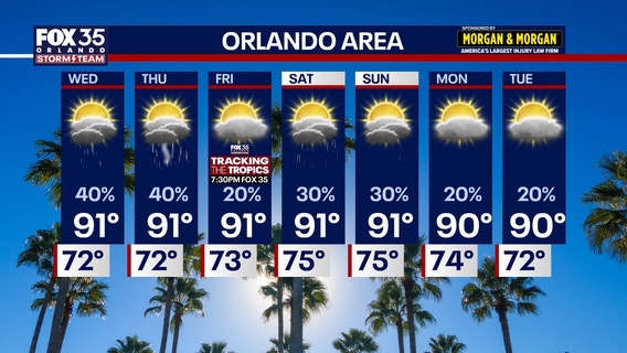

Orlando weather: Hot and humid with highs near 90 in Central Florida
Temperatures continue to rest in the low-90s for the remainder of the week with scattered showers throughout Central Florida.

Orlando weather: Scattered afternoon storms, hotter and drier weather ahead
Partly sunny skies are expected on Wednesday with a few afternoon and evening pop-up showers and storms.


Orlando weather: Storms bring threat of severe weather before sunshine returns later this week
It’s shaping up to be another afternoon of isolated thunderstorms across Central Florida, with a potential for strong to severe thunderstorms.