

Orlando weather: Warm temps, rain chances ahead for Central Florida
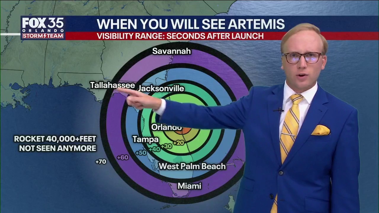
Orlando Weather Forecast: Tracking Artemis Forecast
FOX 35 Storm Team Senior Meteorologist Noah Bergren is tracking showers and clouds for the Artemis launch Wednesday.
ORLANDO, Fla. - A partly cloudy sky will prevail tonight with a bit of an east breeze at 10-20 mph.
A sprinkle is possible, but most places are and will remain dry.
Wednesday's forecast for Orlando
What To Expect:
A higher chance for sprinkles and showers compared to Tuesday.
There will be a batch of showers that come inland from the Space Coast during the afternoon.

For those out near/at Cape Canaveral, it is going to rain briefly during the afternoon, but the expectation is the rain will move out and far enough away by evening for the scheduled launch time. Highs inland in the low 80s and 70s at the beaches with east wind gusts 20–25 mph at times.
CLICK TO DOWNLOAD THE FOX LOCAL APP
Rough surf and rip currents threaten with onshore flow continuing and 2–5' surf through the end of the week. High tides in the early-mid morning the next few days.
Artemis II launch forecast
The first launch window starts on Wednesday, at 6:24 p.m., with a 2-hour window to launch. We are watching the likelihood of showers in the early-mid afternoon to impact Launch Pad 39B.

The good news is these showers should move out before 5 p.m. at Cape Canaveral.


SIGN-UP FOR FOX 35'S BREAKING NEWS, DAILY NEWS NEWSLETTERS
Mild week with low rain chances
Looking Ahead:
Temperatures this week and into the weekend will stay in the mid 80s for highs.

Our onshore wind continues as well, keeping skies partly cloudy with intermittent sunshine. This onshore flow will also keep spotty showers in the forecast.
While it won't be a washout, isolated to scattered showers and storm chances will stick with us just about every day this week.

For Easter Sunday, the data points to a dry morning for Easter egg hunting plans. However, building moisture out ahead of a cold front next week is set to bring the chance of scattered showers on Sunday afternoon.

A pattern change early next week will arrive with the aforementioned cold front. This will help increase shower and storm chances for early parts of next week along with a slight dip in temperatures as highs return to the 70s.
The Source: This story was written with information for the FOX 35 Storm Team.