

Orlando weather: Evening temperatures in the high 60s, rain this weekend
Orlando rain: Heat now, storm chances this weekend
The heatwave continues in Orlando with temperatures expected to be in the 90s through Saturday. However, Saturday night and Sunday morning, there a chances for thunderstorms and rain. FOX 35's Noah Bergren has the latest on the forecast.
ORLANDO, Fla. - Get ready for a warm end of the week with temperatures in the 90s, followed by a windy weekend and a round of Sunday storms.
The forecast: Wednesday night
Tonight: It will be another warm night with lows only dropping into the upper 60s to low 70s.

Orlando weather for April 29, 2026.
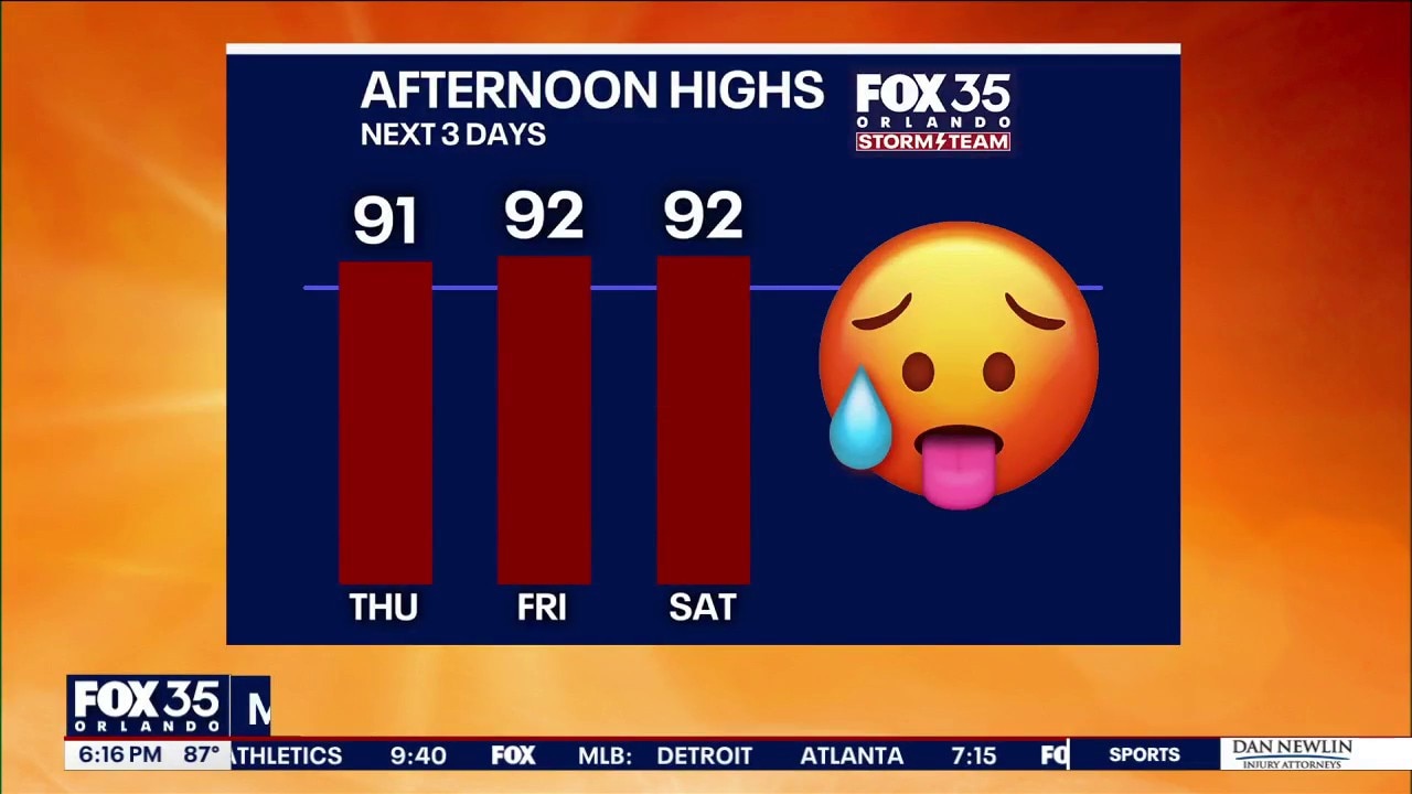
Temperature by area
By 5 p.m., temperatures in Central Florida ranged from the mid to upper 60s.
- Palm Coast: 67 degrees
- Daytona Beach: 67 degrees
- New Smyrna: 67 degrees
- Titusville: 66 degrees
- Cocoa Beach: 69 degrees
- Orlando: 69 degrees
- Ocala: 66 degrees
- Clermont: 66 degrees

Orlando weather for April 29, 2026.
Upcoming weather
With an average low of 63°F for this time of year, tonight will feel several degrees warmer than a typical April evening.
By Thursday, expect mostly sunny skies with highs hitting the low 90s inland and upper 80s at the beaches.
Keep an eye out for a slight chance of showers in northern counties – Alachua, Putnam, Flagler, Volusia, and Marion.

Orlando weather for April 29, 2026.
The weekend: Windy and wild
By Friday, the heat continues with highs in the low 90s, but winds will begin to pick up from the southwest at 10 and 20 MPH.
Saturday will be both hot and windy, featuring southwest gusts between 25 and 35 MPH.
Severe Potential: Strong to severe storms may develop Saturday evening near Jacksonville, Gainesville, and Flagler Beach.

Orlando weather for April 29, 2026.
Looking Ahead: Sunday Setup
The cold front will weaken as it moves south Saturday night before "reforming" over Central Florida early Sunday morning.
Sunday Morning: Expect rain and thunderstorms to start the day, particularly for Orlando and areas to the south.
Clearing Out: Don't cancel your afternoon plans just yet—skies are expected to clear gradually from north to south during the afternoon and evening hours.
The Source: Information in this story was gathered from FOX 35's Noah Bergren.