

Orlando weather: Severe thunderstorm warnings issued

Orlando Weather Forecast PM: May 29, 2025
FOX 35's Noah Bergren has a weather update as showers and thunderstorms move across Central Florida.
ORLANDO, Fla. - A stormy stretch of weather continues across Central Florida as a cold front pushes into the region, bringing the potential for severe storms and a noticeable cooldown by the weekend.
What will the weather look like tonight?
What to expect:
Showers and thunderstorms popping up across the region through the rest of the afternoon. Best chances of the most widespread and intense storms will take place from around 4pm-9pm. This is when we could see storms become on the stronger side or reach severe strength.
We are in a Marginal Risk or level 1 out of 5 for severe weather for the rest of today.
Main impacts for the evening will be gusty winds, hail up to quarter sized, heavy downpours, and frequent, vivid lightning. Most of these thunderstorms will fizzle out by midnight. There will still be lingering showers through the overnight.
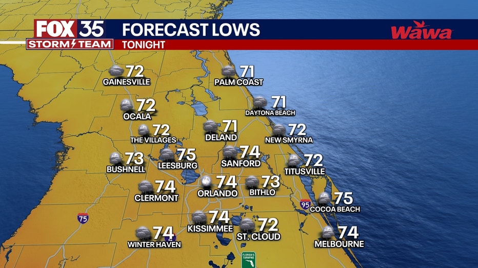
Temperatures through the overnight will be through the low 70s with muggy conditions.
What will the weather look like Friday?
FOX 35 Weather Impact Day
Timeline:
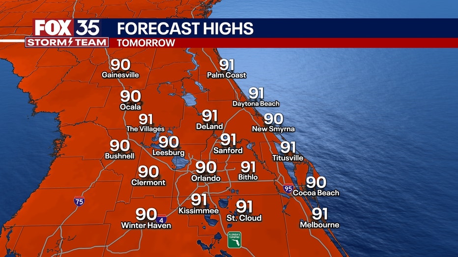
On Friday, our daily afternoon storms will start to fire up than we’ve seen in recent days, our daily afternoon storms will start up at around noon. This is due to a cold front that will amp up storm energy earlier on in the day. Expect on-and-off storms throughout the day, starting with gloomy, humid and unsettled conditions.
Parts of the region is back under a Marginal Risk or level 1 out of 5 for severe weather.
Main impacts for the evening will be gusty winds that could be damaging, hail up to quarter sized, heavy downpours, and frequent, vivid lightning.
What will the weather look like this weekend?
Looking ahead:
Saturday: FOX 35 Weather Impact Day
Early Saturday morning, the cold front will push through the region. Timing right now starts to impact the northwestern parts of our viewing area at about 4AM, pushing into Orlando at about 8AM with showers tapering off by 2PM.
Any plans later on Saturday afternoon look good to go! Cooler air will push in behind the front, creating breezy conditions Saturday afternoon and evening. Because of the cooler air, temperatures will not be as hot on Saturday with temperatures in the mid-80s and overnight lows in the upper 60s.
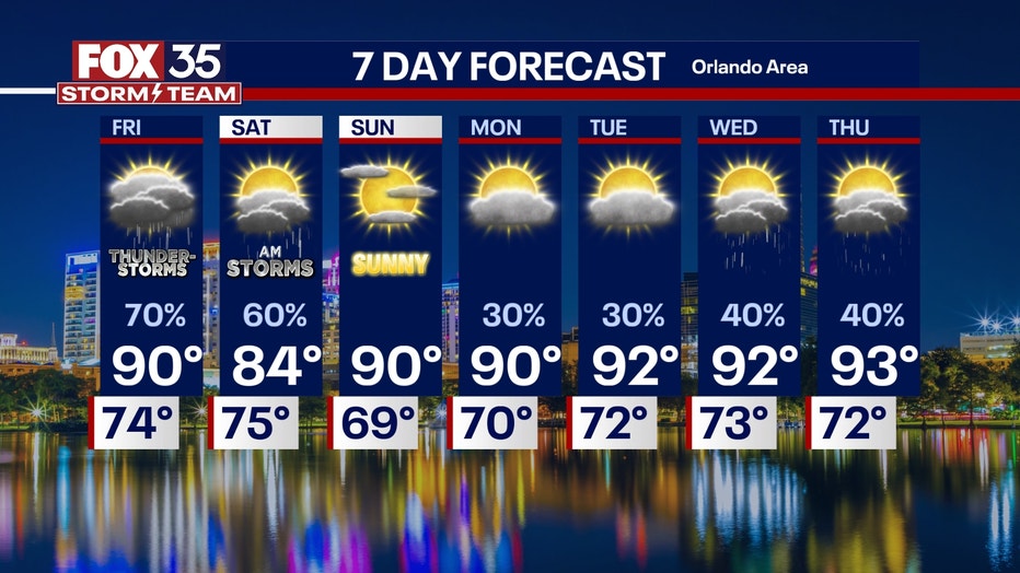
Sunday: Start of Hurricane Season
Rain chances remain low on Sunday with only a pop-up shower or stray thunderstorm. Highs will bump back into the upper 80s with partly cloudy skies.
Something else that will be picking up next week will be the Saharan Dust sweeping off the coast of Africa, especially midweek. This could decrease air quality, firing up those who have allergies, and make for a more milky and muted look to our normally brilliant blue skies. On the bright side, it will make for more vivid and colorful sunrises and sunsets and keeping hurricane activity at bay for the first week of June.
Orlando 7-Day Weather Forecast

FOX 35 Storm Tracker Radar
Track live when storms move across your area using the FOX 35 Storm Tracker Radar below.

More radar maps from FOX 35 Storm Tracker Radar
- Brevard County
- Flagler County
- Lake County
- Marion County
- Osceola County
- Orange County
- Polk County
- Seminole County
- Sumter County
- Volusia County
- U.S./National Radar
STAY CONNECTED WITH FOX 35 ORLANDO:
- Download the FOX Local app for breaking news alerts, the latest news headlines
- Download the FOX 35 Storm Team Weather app for weather alerts & radar
- Sign up for FOX 35's daily newsletter for the latest morning headlines
- FOX Local: Stream FOX 35 newscasts, FOX 35 News+, Central Florida Eats on your smart TV
The Source: This story was written based on information shared by the FOX 35 Storm Team on May 29, 2025.