

Orlando weather: Central Florida faces record-high heat. When will relief arrive?

Orlando Weather Forecast PM: May 19th, 2025
FOX 35 Storm Team Meteorologist Noah Bergren is tracking very hot weather for a few more days and the forecast for Memorial Day weekend.
ORLANDO, Fla. - Central Florida is experiencing a stretch of unusually hot and dry weather, with temperatures climbing into the mid-to-upper 90s through midweek.
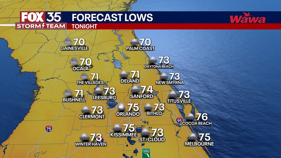
What will the weather look like tonight?
What to expect:
Partly cloudy skies overnight. Warm and muggy. Plan for morning lows to dip down into the low and middle 70s.
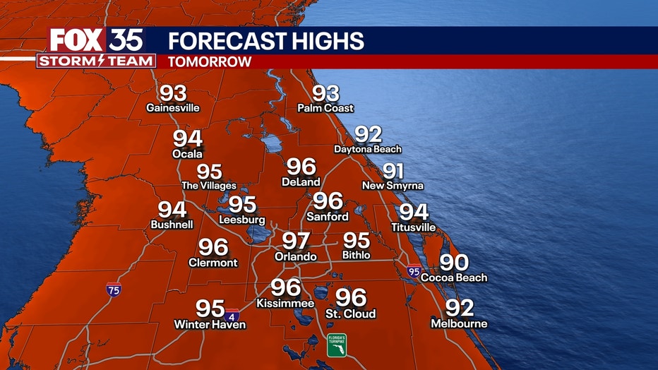
What will the weather look like on Tuesday?
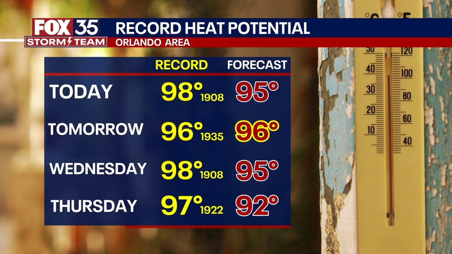
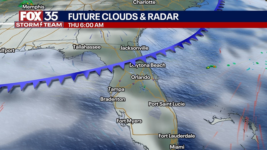
Tuesday could bring record-breaking heat in several inland areas, and while a weak front is expected Thursday, it’s unlikely to bring significant relief. Rain chances remain low, mostly confined to southern Florida.
What will the weather look like for the rest of the week?
Looking ahead:
A strong ridge of high pressure will continue to dominate Central Florida for much of the workweek, keeping temperatures consistent with what we've experienced over the weekend.
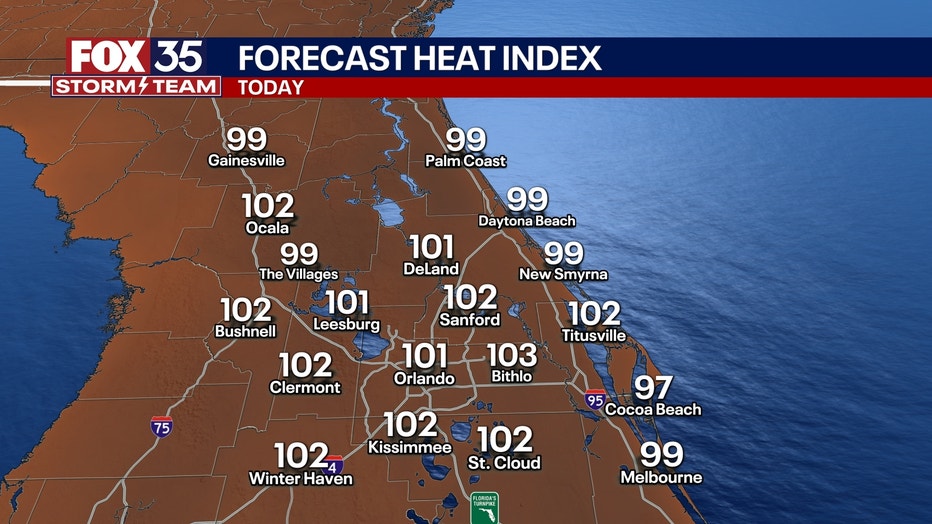
Highs through midweek will peak around the mid 90s with heat indices reaching the low 100s when factoring in humidity.
A small amount of relief from the heat may finally arrive toward the end of the week as a weakening cold front approaches on Thursday. While the front itself isn't expected to be particularly strong, it could help break down the persistent ridge of high pressure and bring a few very isolated showers and storms.
Behind the front, temperatures on Friday and into the weekend will remain above normal as highs climb into the low 90s.
Orlando 7-Day Weather Forecast

FOX 35 Storm Tracker Radar
Track live when storms move across your area using the FOX 35 Storm Tracker Radar below.

More radar maps from FOX 35 Storm Tracker Radar
- Brevard County
- Flagler County
- Lake County
- Marion County
- Osceola County
- Orange County
- Polk County
- Seminole County
- Sumter County
- Volusia County
- U.S./National Radar
Stay connected with FOX 35
- Download the FOX 35 News app for latest news, weather, and traffic alerts
- Download the FOX 35 Storm Team Weather app for live, interactive radar
- Visit FOX35Orlando.com/weather for interactive radar, plus updated weather graphics, maps, and images
The Source: This story was written based on information shared by the FOX 35 Storm Team on May 19, 2025.