

Orlando weather: Low rain chances Sunday; Thunderstorms possible on Monday

Orlando AM Weather Forecast: June 1, 2025
A quieter Sunday is unfolding across Central Florida. Storm Team Meteorologist T.J. Springer lets us know if we'll see any storms today and breaks down this year's hurricane season.
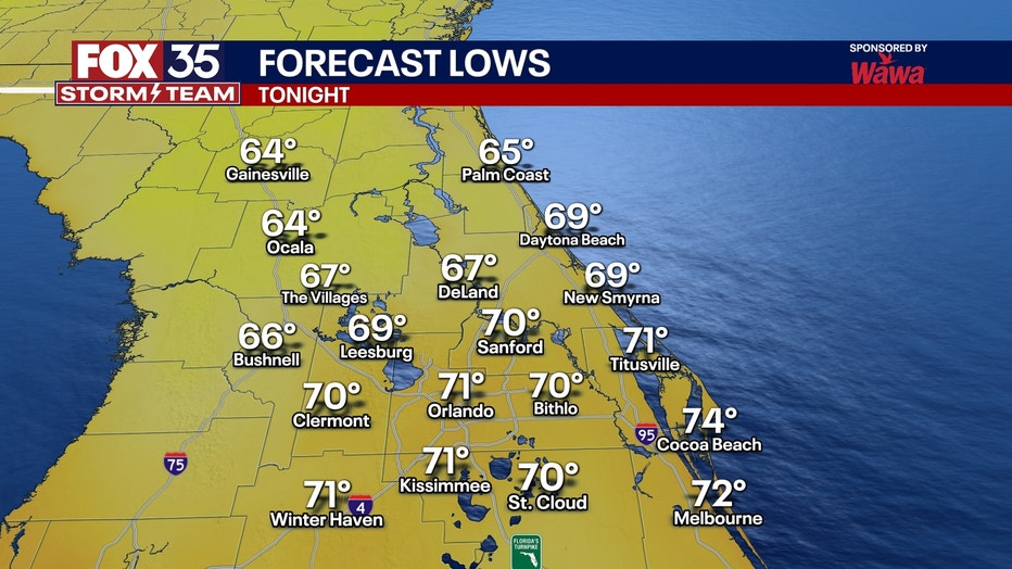
What will the weather look like Sunday evening?
What to expect:
ORLANDO, Fla. - Rain chances remain low on Sunday with only a pop up shower or stray thunderstorm for the rest of the evening and overnight. This is due to the front that moved through on Saturday stalling to our south possibly firing up a few storms south of the metro in mainly southern Brevard/ Osceola. A stray storm may pop up along the turnpike. Few clouds will stick around Sunday night with lows in the low 70s.
What will the weather look like on Monday?
Looking ahead:
The front that moved through Saturday still seems to linger over the state headed into Monday. This will keep some storm energy around to start off the work week.
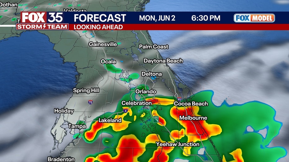
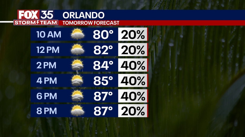
A wave of energy once again brings the possibility of showers and storms through Monday afternoon. These storms will be hit and miss and although there are no widespread severe chances. Although, we still may see an isolated strong thunderstorm. A mix of sun and clouds is on tap for Monday with highs in the upper 80s.
Mainly clear skies are forecast for Monday night with lows in the upper 60s and low 70s.
What will the remainder of the week look like?
We fall back into the typical afternoon sea-breeze driven showers and thunderstorms starting to take back hold on Tuesday through next week.
Highs look to stay close to seasonable norms for this time of year. With an increase in clouds highs could stay in the upper 80s but ultimately be near 90° with lows in the low 70s.
Something else that will be picking up next week will be the Saharan Dust sweeping off the coast of Africa, especially midweek. This could decrease air quality, firing up those who have allergies, and make for a more milky and muted look to our normally brilliant blue skies.
On the bright side, it will make for more vivid and colorful sunrises and sunsets and keeping hurricane activity at bay for the first week of June.
Tracking the Tropics:
The 2025 Atlantic hurricane season officially begins on June 1, and much like last year, the FOX 35 Storm Team expects a lot of ocean heat content to fuel the potential for an above-average season.
As of Sunday, there is no tropical actvity expected over the next seven days.

The 2025 Hurricane Season Begins: No Activity Expected in First Week
FOX 35 Meteorologist Laurel Blanchard breaks down what could be expected this hurricane season and if there is any activity expected for the first few days of the 2025 Atlantic Hurricane Season
Orlando 7-Day Weather Forecast

FOX 35 Storm Tracker Radar
Track live when storms move across your area using the FOX 35 Storm Tracker Radar below.

More radar maps from FOX 35 Storm Tracker Radar
- Brevard County
- Flagler County
- Lake County
- Marion County
- Osceola County
- Orange County
- Polk County
- Seminole County
- Sumter County
- Volusia County
- U.S./National Radar
STAY CONNECTED WITH FOX 35 ORLANDO:
- Download the FOX Local app for breaking news alerts, the latest news headlines
- Download the FOX 35 Storm Team Weather app for weather alerts & radar
- Sign up for FOX 35's daily newsletter for the latest morning headlines
- FOX Local: Stream FOX 35 newscasts, FOX 35 News+, Central Florida Eats on your smart TV
The Source: This story was written based on information shared by the FOX 35 Storm Team on June 1, 2025.