

Orlando weather: Temps take a dip overnight with a warmer, breezy Tuesday ahead

Orlando Weather Forecast: April 22, 2024
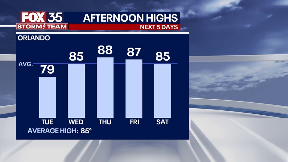
Monday was a cool day, and that trend will continue into Tuesday due to a cold front that passed through the area on Sunday. Temperatures will begin to warm up mid-week, and there will be lots of sunshine.
ORLANDO, Fla. - It will be a cool night under clear skies. Winds will calm down some but remain out of the northeast. Lows will fall to the 50s inland and the low 60s near the coast.
It's another seasonably cool day thanks to a light breeze out of the northeast. Under mostly sunny skies, highs will reach into the mid-to-upper 70s across Central Florida. This will be our last cool day for a while, so enjoy it while you can!


BEACH FORECAST: A breezy onshore wind out of the NE will keep Tuesday's highs in the mid-70s. Surf could be rough, with a moderate risk of a rip current.

THEME PARK FORECAST: It should be a fair and pleasant day at the parks tomorrow with low humidity. Highs will reach near 80 with a light NE wind and plenty of sunshine.

LOOKING AHEAD: High pressure builds over the western Atlantic again, which will help keep us warm and dry the rest of the week. Highs will climb back into the mid-80s on Wednesday and even reach the upper 80s on Thursday before coming back down some into the weekend. At this time, rain chances look very limited.


Some long-range computer models point to the mid-and upper 90s during the first week of May. We're also facing a very dry period over the next 10-14 days, with our first rain chance holding off until then. This, combined with warming temperatures into the 80s to near 90s, will result in a moderate to high risk for fire danger.

Orlando Hour-by-Hour Forecast

Behind this cold front, surf's up with 5-6 foot waves and a moderate to high risk for rip currents at our beaches. If entering the water, swim only near a lifeguard.
Our typical high (what's considered climatologically normal) is 85° so temps will be running about 8°-10° cooler than those levels. Temps will quickly recover to seasonal normals by midweek.
Readings will start rising to above-normal levels into early May, when upper 80s to low 90s will become common. Some long-range computer models point to mid and upper 90s during the first week of May.
We're also facing a very dry period over the next 10-14 days, with our first rain chance holding off until the first week of May.
This combined with warming temperatures into the 80s to near 90s will result in a moderate to high risk for fire danger.
Orlando 7-Day Forecast
