

Dangerous heat index over 100° continues in Central Florida this weekend

Weather Forecast: June 17, 2022
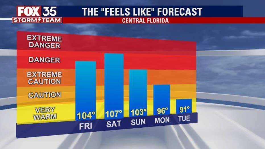
Orlando and Central Florida will experience feels-like temperatures in the 100s on Saturday, which is why the FOX 35 Storm Team has declared Saturday to be a FOX 35 Weather Impact Day.
ORLANDO, Fla. - HEAT ADVISORY: A heat advisory has been issued for Volusia, Lake, Orange, Seminole, Osceola, and Brevard counties from 2 p.m. - 8 p.m. Saturday as temperatures will near 100 degrees in some spots, and the heat index – the "feels like" temperature – could be higher, up to 111 degrees.
At those temperatures, heat illness – heat exhaustion, heat stroke, sunburn – are possible. It's recommended to stay hydrated, stay inside and in air-conditioned rooms, and avoid the sun.
RELATED: Heat exhaustion vs. heat stroke: Signs and symptoms to know
WHAT IS THE WEATHER FORECAST FOR TODAY AROUND ORLANDO?
Today's forecast high: 96 degrees
Tonight's forecast low: 76 degrees
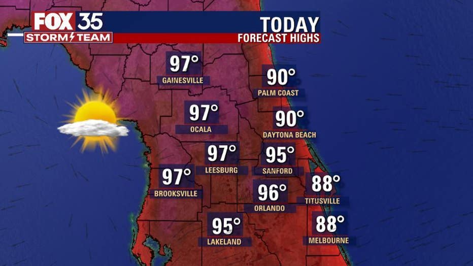
MAIN WEATHER CONCERNS:
Scorching heat continues today and tomorrow. Afternoon highs will reach the upper 80s to low-90s along the coast and reach the mid to upper-90s across the interior. Heat index values will range from 103 to 107+ degrees through the start of the weekend.
Seminole County is expected to activate the Extreme Weather Plan as temperatures are expected to get near 100 degrees on Saturday.
"This Plan is activated when the National Weather Service issues a Heat Advisory, which is expected tomorrow, Saturday," officials said Friday. In Florida, a Heat Advisory is issued when the heat index is expected to rise above 108.
DOWNLOAD: FOX 35 NEWS APP | FOX 35 STORM TEAM WEATHER APP
There is a Heat Advisory until 6 p.m. along the immediate west coast of the Florida peninsula with heat index values of 106 to 110 degrees. Stay safe in this heat, drink plenty of water, stay inside the a/c and wear loose-fitting clothing. Storm chances will be limited this afternoon.
WHAT IS THE WEATHER FORECAST FOR WALT DISNEY WORLD, UNIVERSAL, AND SEAWORLD?
Park visitors can expect high heat and humidity. High temps at the parks will hit near 95+ degrees with feels-like temperatures in the triple digits, so make sure you stay hydrated and take breaks in the a/c.
WHAT IS THE WEATHER FORECAST FOR THE BEACHES IN CENTRAL FLORIDA?
If you are heading out to the beach today, you can expect mostly sunny skies. Highs will be in the upper-80s with feels-like temperatures in the upper-90s. Pack plenty of water and don't forget to reapply sunscreen. Rip current risk remains in the moderate range.
LOOKING AHEAD:
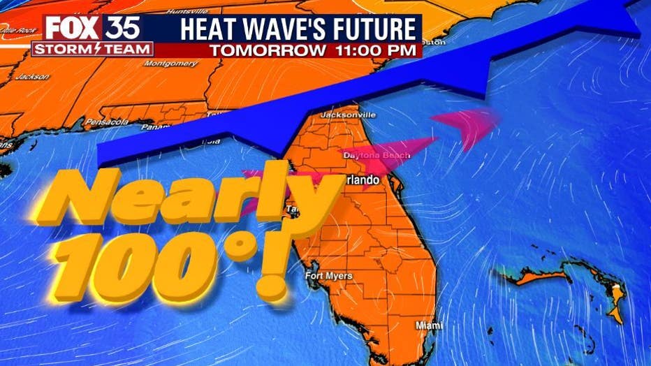
Hot and steamy conditions will continue through Saturday. Afternoon highs will near 100 degrees with heat index values up to 107+ degrees. Make sure you take breaks inside the A/C, wear lightweight clothing and check on your elderly neighbors.
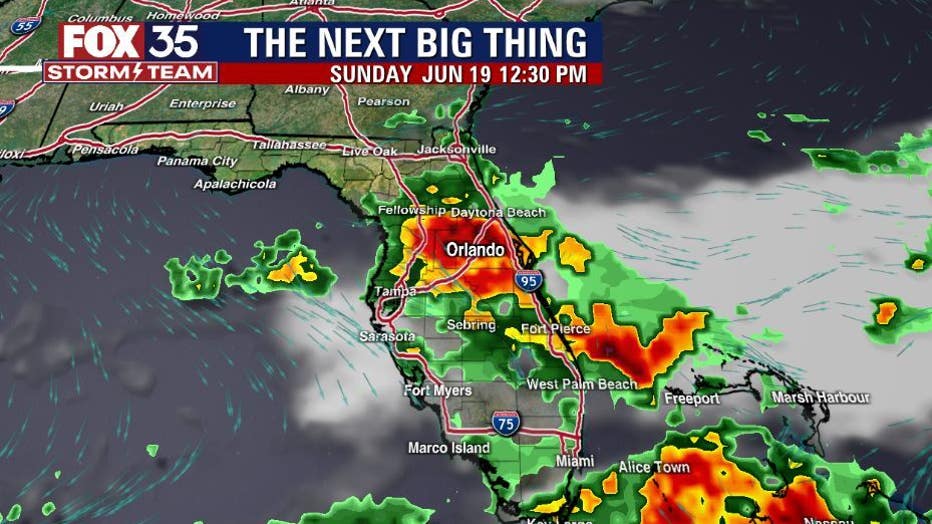
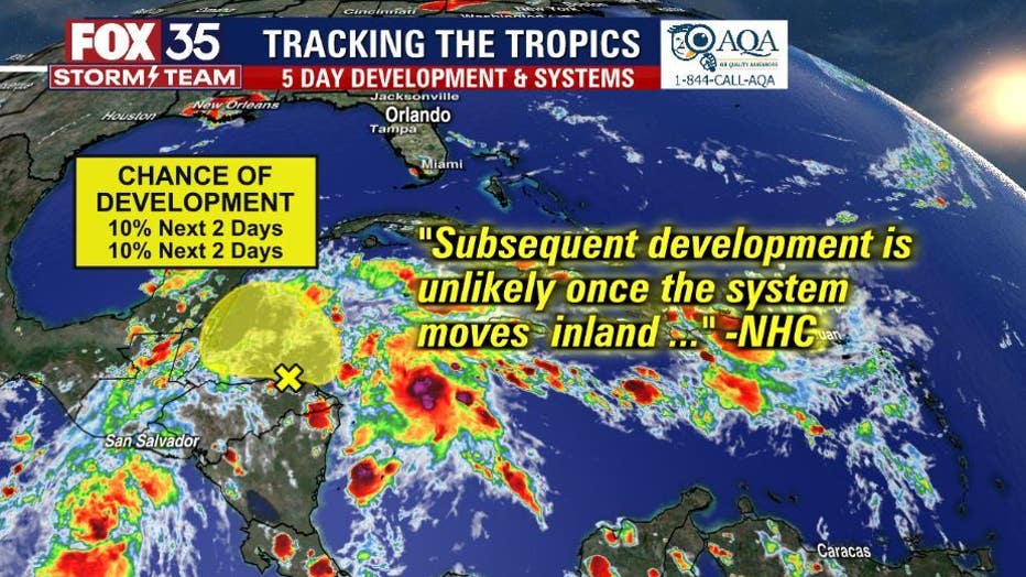
Storm chances are on the rise this weekend. Coverage will be at 50% on Saturday afternoon and 60% on Sunday. As for the tropics, an area of low pressure remains along the coast of Honduras. It has a LOW 10% chance for development within the next 5 days. The FOX 35 Storm team continues to track the tropics and will update you if anything changes