

Orlando weather: Hot, humid with daily afternoon storms
Orlando Weather: Afternoon Storms to Round out the Weekend
Widespread rain and some storms are being tracked tonight and will be once again as storms start to pick up tomorrow afternoon. Lots of events at the theme parks are back so here's Laurel's forecast so you can make the most of it.
ORLANDO, Fla. - We are stepping back into our standard rainy season setup in Central Florida, featuring plenty of morning sunshine followed by firing afternoon sea breezes.
Rain chances start near 50% this weekend, driven primarily by the East Coast sea breeze as it moves inland.
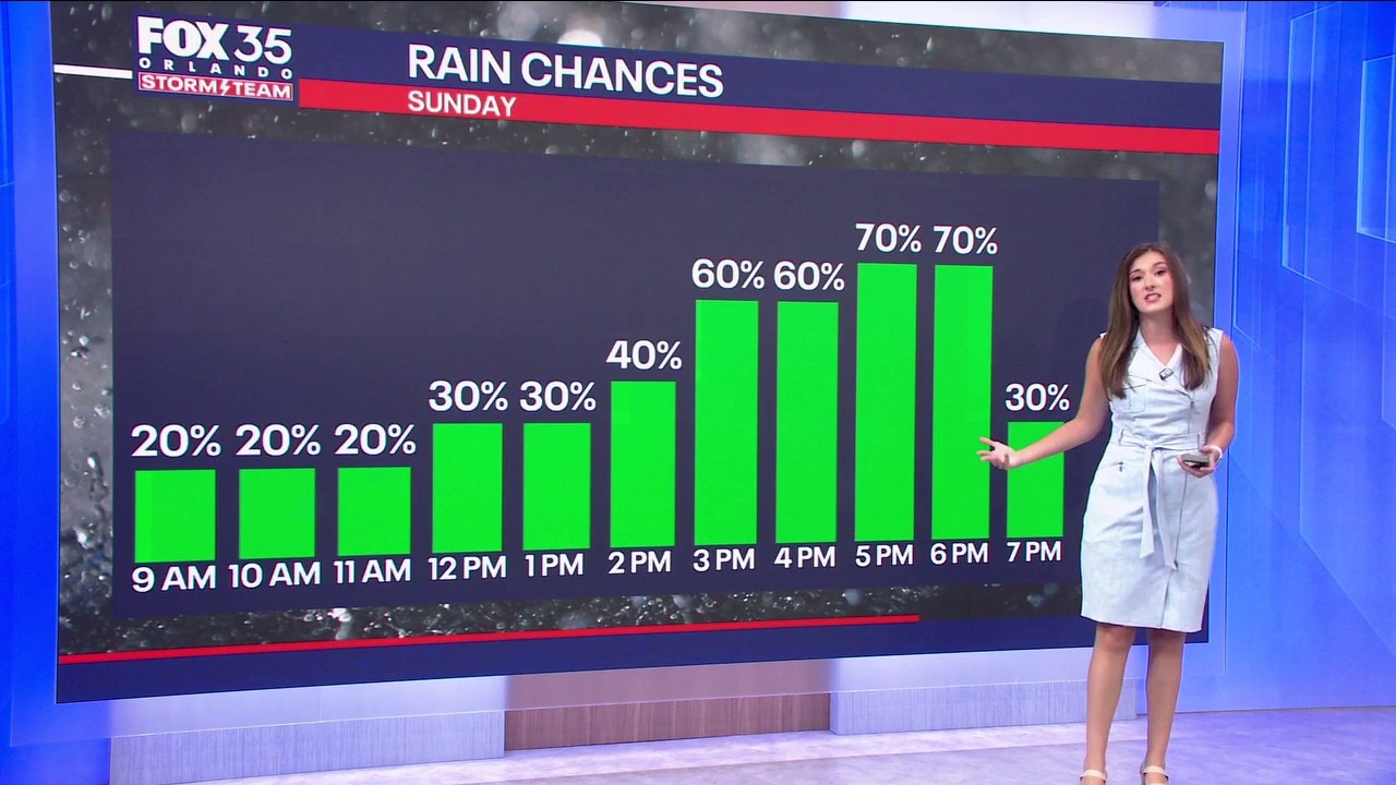
As atmospheric moisture builds into early next week, expect storm coverage to pick up. A bit more upper-level energy moving through will lead to numerous more storms on Sunday.
Rain chances hit 60% from Sunday through Tuesday, with afternoon collision storms developing near Orlando and pushing toward the interior.
While washouts are not expected, any storm that develops will be capable of torrential downpours, frequent lightning, and localized gusty winds before tapering off after sunset.
STEAMY CONDITIONS PREVAIL
Air temperatures will remain right on target for late August, with afternoon highs topping out in the lower-to-middle 90s. However, high humidity will keep conditions feeling steamy.
Heat indices ("feels-like" temperatures) will routinely reach 102° to 106° before afternoon storms arrive to provide localized cooling relief. If you have outdoor plans during peak midday heat, take frequent shade breaks and stay hydrated.
TRACKING THE TROPICS
Tropics forecast: Tracking the Remnants of Dolly
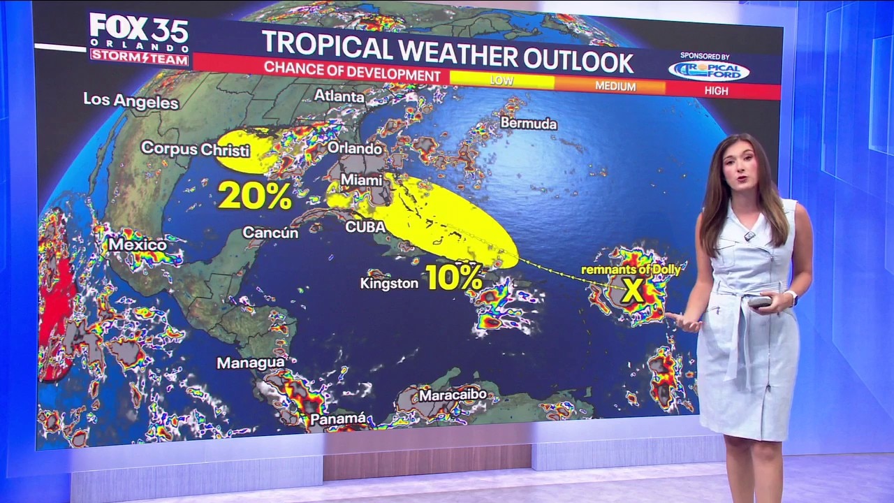
In the Atlantic basin, conditions remain relatively quiet for late August, but the Storm Team is keeping an eye on a couple of broad areas of low pressure. There are 2 areas of interest. There is now a 10% chance of tropical (in this case, re-formation) of the remnants of Tropical Storm Dolly. The dissipated system will continue moving west toward the Leeward Islands with a low chance of redevelopment. Strong wind shear ahead of the system is expected to tear apart what remains of Dolly, continuing a trend where strong shear has kept tropical systems in check this season. The next name up is Edouard - but if the remnant moisture does not entirely fall apart and does manage to reform back to tropical storm strength, a new re-formed system would keep the name "Dolly" There is also a 20% chance of development in the Gulf. A weak area of low pressure over the northern Gulf of Mexico is producing disorganized showers. The warm ocean water will increase the amount of thunderstorms in the gulf and will be moving west before it most likely gets caught up in a front. Neither system poses an immediate threat to Central Florida, but we will keep watching them closely over the next week
In the Atlantic basin, conditions remain relatively quiet for late August, but the Storm Team is keeping an eye on a couple of broad areas of low pressure. The remnants of Tropical Storm Dolly continue moving west toward the Leeward Islands with a low chance of redevelopment.
Strong wind shear ahead of the system is expected to tear apart what remains of Dolly, continuing a trend where strong shear has kept tropical systems in check this season.
Meanwhile, a weak area of low pressure over the northern Gulf of Mexico is producing disorganized showers, though any development will be slow. Neither system poses an immediate threat to Central Florida, but we will keep watching them closely over the next week.
The Source: This story was written based on information provided by FOX 35 meteorologist T.J. Springer on August 29, 2026.