

Disturbance moving across Central Florida causes coastal flooding, strong winds

Tracking the Tropics: Sept. 20
FOX 35 Meteorologist Kristin Giannas is tracking Hurricane Teddy and Tropical Storm Beta.
ORLANDO, Fla. - While several tropical storms and a hurricane moves through the tropics, a disturbance right off the coast of Central Florida is causing heavy rain, strong winds, and rough surf.
FOX 35 meteorologist Kristin Giannas is monitoring activity in the tropics.
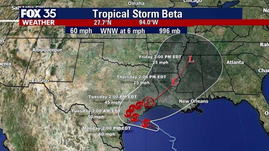
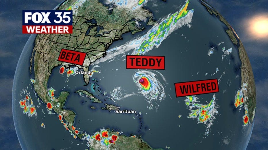
TROPICAL STORM BETA
Tropical Storm Beta is moving slowly west-northwestward towards the Texas coast. The National Hurricane Center (NHC) said in its latest advisory that it is just about 140 miles southeast of Galveston, Texas.
They said that Beta currently has maximum sustained winds near 60 mph and little change in strength is forecasted. It should weaken after moving inland.
Beta is expected to make landfall on the coast of Texas on Monday.
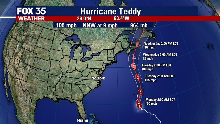
HURRICANE TEDDY
Hurricane Teddy is reportedly moving northwest at 9 mph. It is expected to approach Bermuda on Sunday night, passing east of the island on Monday. It will then approach Nova Scotia on Wednesday.
The NHC said that Teddy currently has maximum sustained winds of 105 mph. It is forecasted to remain a powerful hurricane through Monday, becoming a post-tropical cyclone on Tuesday.
TROPICAL DEPRESSION WILFRED
Wilfred has weakened into a tropical depression and is located about 1,340 miles west of the Cabo Verde Islands. It is moving west-northwest at 20 mph, the NHC said.
The depression has maximum sustained winds of 35 mph. Weakening is anticipated and it should become a remnant low within a couple of days.
OTHER SYSTEMS
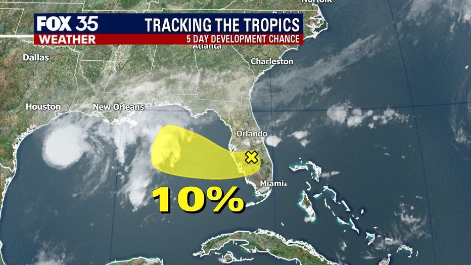
There are two other disturbances moving through the tropics.
The first one is located a few hundred miles south of the Azores and is producing showers. The NHC expects the system to start moving eastward in a couple of days and it could become tropical or subtropical. It has a 60% chance of development.
The other disturbance is a small low-pressure system and that produced thunderstorms over Florida on Sunday. Significant development of this system is not anticipated by the NHC. It has just a 10% chance of formation.

Strong winds, rough seas along the Central Florida coast
Beach patrol is warning beachgoers about the winds along the coast on Sunday.
TRACK THE TROPICS: Visit the FOX 35 Orlando Hurricane Center for the latest in the tropics, including daily updates, live radar, and severe weather alerts
The latter disturbance is causing strong winds, heavy rain, and rough surf along the coast. A coastal flood warning is in effect from Flagler to Brevard County. Beaches could see life-threatening rip currents with large breaking waves between 6 to 10 feet. In addition, northeast winds are picking up and gusts could reach over 35 mph.
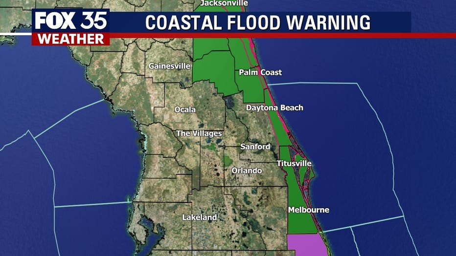
Significant coastal flooding continued on Sunday.
WEATHER ALERTS: Download the FOX 35 Weather App to track the tropics on your phone, receive severe weather alerts, and get the latest daily forecasts
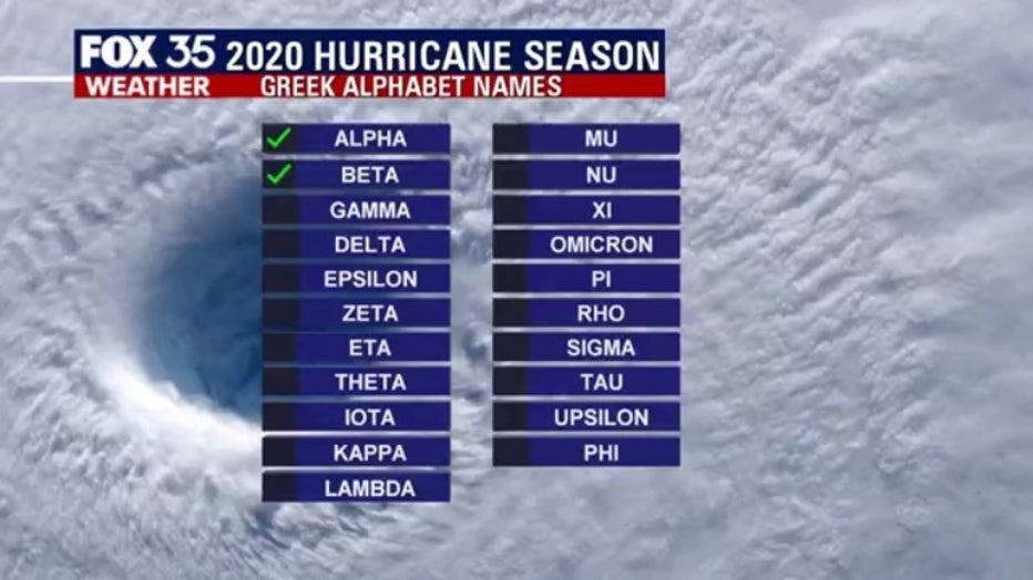
The 2020 Atlantic hurricane season has blown through the entire list of names for storms and has moved onto the Greek alphabet for any other storms that develop. The last time this backup list of names was used was in 2005. There were 28 named storms that year.
Forecasters have predicted that this season will have more activity than normal. For example, NOAA predicted an above-average season, with 13 to 19 named storms. Six to 10 of those would become hurricanes and three to six of those are forecasted to become major hurricanes (Category 3 or higher).
In comparison, the 2019 Atlantic Hurricane season had 18 named storms, matching 1969 for the fourth most-lively season in the past 150 years.
Hurricane season runs through November 30.
Tune in to FOX 35 Orlando for the latest updates on the tropics.