

Florida tropics update: Disturbance headed toward Gulf to bring heavy ring with it

Tropical Update PM: June 30, 2025
FOX 35 Senior Meteorologist Noah Bergren has the latest conditions in the tropics. The 2025 Atlantic Hurricane Season runs July 1 - November 30. Download the FOX Local app for tropical alerts and notifications.
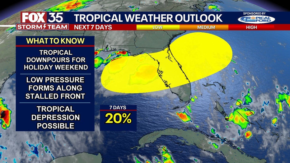
ORLANDO, Fla. - A potential tropical disturbance headed towards the Southeastern United States is likely to bring heavy rains to the state over the Fourth of July weekend, according to the FOX 35 Storm Team and the National Hurricane Center.
The NHC said in its latest update that a frontal boundary is expected to stall and weaken off the U.S. Gulf Coast this week. An area of low pressure could then develop and potentially being subtropical or tropical, the NHC said. As of Monday night, the chances of development were still at 20%.
What can we expect in Florida?
The FOX 35 Storm Team said this sytem will likely bring daily storms, showers, and downpours to the state. Some may be severe with strong winds and large hail.
Florida July 4 Forecast
The FOX 35 Storm Team says this unsettled weather pattern will heighten the risk of flooding across Central Florida, especially during peak holiday travel and events.
Residents and visitors are encouraged to monitor forecasts closely as the situation evolves.
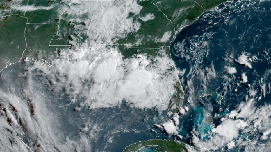
GOES Image Viewer by NOAA
July 4 travel at Orlando International Airport
More than 1.4 million people are expected to fly into or out of Orlando International Airport (MCO) this week ahead of the Fourth of July holiday.
Here are the top 5 busiest days expected at MCO:
- Sunday, July 6 - 175,559 (arrivals & departures)
- Sunday, June 29 - 174,053
- Monday, July 7 - 167,536
- Monday, June 30 - 166,746
- Saturday, July 5 - 166,508
FOX 35 Storm Tracker Radar and Live Weather Cameras
Track live when storms move across your area using the FOX 35 Storm Tracker Radar below. You can also watch as heavy rain moves across Central Florida on our Live Weather Cameras' page here.
More radar maps from FOX 35 Storm Tracker Radar
- Brevard County
- Flagler County
- Lake County
- Marion County
- Osceola County
- Orange County
- Polk County
- Seminole County
- Sumter County
- Volusia County
- U.S./National Radar
STAY CONNECTED WITH FOX 35 ORLANDO:
- Download the FOX 35 News app for breaking news alerts, the latest news headlines
- Download the FOX 35 Storm Team Weather app for weather alerts & radar
- Sign up for FOX 35's daily newsletter for the latest morning headlines
- FOX Local: Stream FOX 35 newscasts, FOX 35 News+, Central Florida Eats on your smart TV
The Source: The information in this article comes from the National Hurricane Center (NHC) and the FOX 35 Storm Team.