

TIMELINE: When will tropical rain arrive in Orlando, and how long will it last?

Tropical Update PM: July 1, 2025
A possible tropical system is expected to bring heavy rain to Central Florida. The National Hurricane Center is giving it a 40% chance of development over the next seven days.
ORLANDO, Fla. - Forecasters at the National Hurricane Center say a weak area of low pressure could form near the southeastern U.S. Atlantic or Gulf coasts this weekend and there is an increasing chance it could gradually strengthen into a tropical or subtropical depression as it stalls over Florida.
The Hurricane Center gives the system a near 0% chance of formation in the next 48 hours, and a 40% chance over the next seven days.
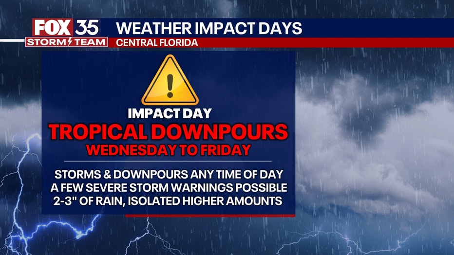
Stormy pattern expected through the week in Florida
What we know:
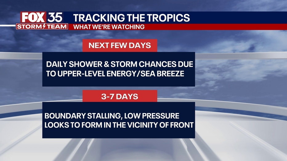
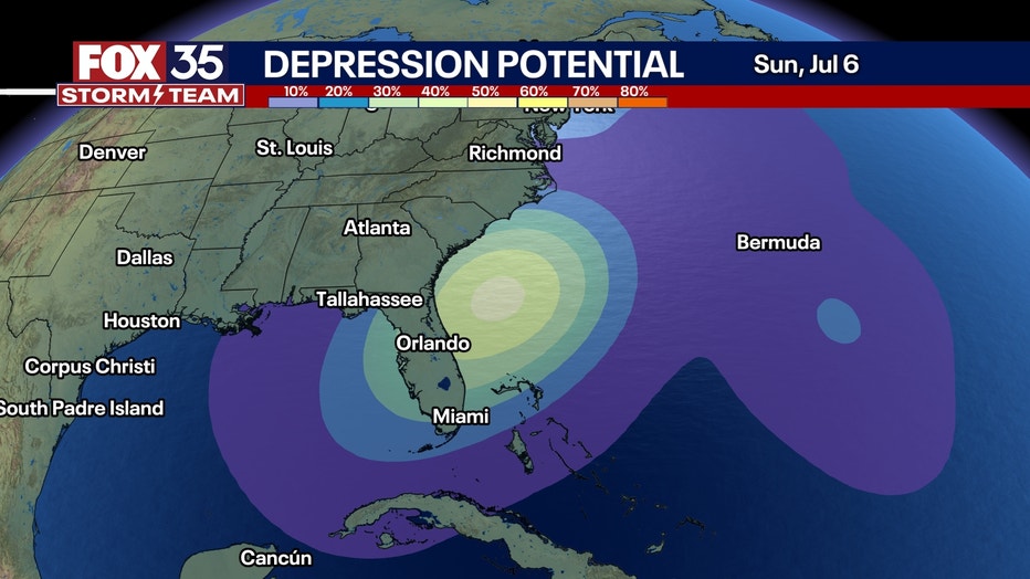
The National Hurricane Center (NHC) is tracking a possible tropical or subtropical system that could emerge from the northeastern Gulf this week.
The system is expected to stall over Florida with chances of development over the next week now increasing to 40%. The disturbance is expected to deliver heavy rainfall and widespread thunderstorms.
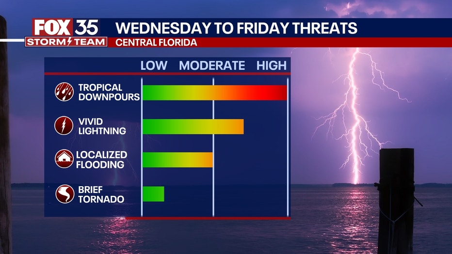
The tropical weather pattern will bring high humidity, and numerous daily storms that are not just limited to the afternoon. Some storms at times may turn severe (60+ MPH wind gust and/or large hail of quarter size or larger). Any storms will produce extremely heavy rates of rain at times.
Through the end of the week, although rain totals will vary immensely across the area based on where the biggest cells form, with several places will get over five inches of rain.
What we don't know:
Meteorologists have not pinpointed exactly where or if a defined tropical system will develop.
When will the heaviest rain arrive, and how long will it last?
Timeline:
A possible tropical system may form over the northeastern Gulf, bringing heavy rain to Central Florida over the next several days.
Regardless of development, forecasters warn that heavy rainfall is possible across parts of the Southeast, with the west-central Florida coast most likely to be affected. The heaviest rain will arrive on Thursday and linger into Friday, making Independence Day a washout for many across the region.
What will Orlando's weather be like on Wednesday?
Wednesday, the rain will be a lot more typical of summer in Florida. Even though rain chances are on the rise midweek, with tropical downpours expected, they'll be developing in the afternoon.
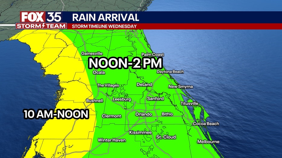
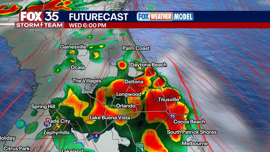
As the sea breeze moves in during the afternoon, with some "energy" aloft heading our way, we'll see numerous showers and thunderstorms from essentially early afternoon onward. Showers and storms will linger right into Wednesday night before becoming more scattered.
What will Orlando's weather be like on Thursday?
Showers and storms look to be the most widespread on Thursday. There will likely still be some dry periods on Thursday AM before rain becomes more widespread in the afternoon. This is when the upper-level disturbance is essentially directly overhead.
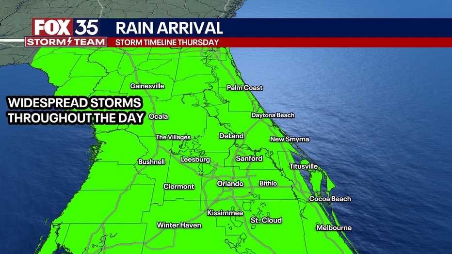
There are some communities with Fourth of July festivities on Thursday evening, but torrential rain is expected. If you have any outdoor plans, potentially plan on a back-up for anything that could get rained out. The rain looks to linger through overnight, right into our Friday AM.
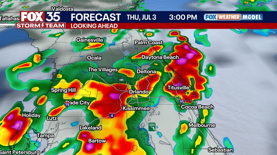
What will Orlando's weather be like on Fourth of July?
There looks to be some dry periods on Friday as well, but rain chances, just like Thursday, will be with us throughout the day.
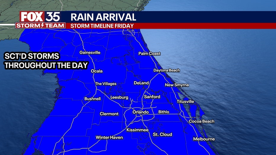
The upper-level energy in the atmosphere will be working east. This means that the best lift or dynamics won't be overhead. But what we will have is the stalled front on top of us. That front will still aid in keeping numerous showers and storms in the forecast throughout the day on Friday.
Fireworks festivities and launches during the evening could be questionable, but it's something we'll be monitoring closely.
How much rain will the Orlando area get?
What To Expect:
Widespread showers and thunderstorms are expected across Central Florida throughout the week.
Rainfall totals will vary across the region, but several inches are expected to fall in nearly every county by the weekend.
Coastal areas from the eastern Florida Panhandle southward through the Big Bend and into the Sarasota area will likely see the highest rain totals this week. Parts of Florida's Big Bend from about the Perry area through Cedar Key may receive as much as 6 to 10 inches.
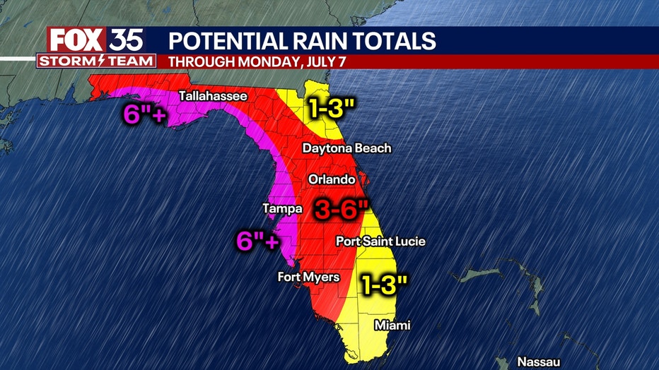
Orlando could see upwards of 5 to 8 inches of rain, with some locally higher amounts.
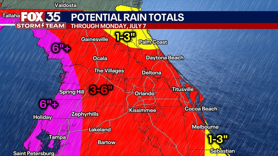
Heavy rain is also expected along the Atlantic Coast of Florida from south of Jacksonville through Daytona Beach, as well as in communities along the Space Coast from Cocoa Beach to Melbourne.
SIGN-UP FOR FOX 35'S BREAKING NEWS, DAILY NEWS NEWSLETTERS
Daily downpours and storms are likely, and meteorologists say the wet weather won’t be confined to the usual afternoon hours.
Looking Ahead:
The exact timing for the heaviest rain still needs to be fine-tuned as we move through this week, but models show several inches of rain could fall over the next seven days. By Saturday, as the tropical moisture moves over the Atlantic Ocean, the chances of a tropical depression forming off the Southeast United States increases.
Big picture view:
AAA projects a record 72.2 million Americans are expected to travel during the July Fourth weekend, driven by the holiday falling on a Friday.
CLICK TO DOWNLOAD THE FOX LOCAL APP
Flooding, rain, lightning, and possible flight delays are poised to impact travel from Florida along the eastern seaboard. Cities from Tampa and Orlando to New York and Boston may see weather-related disruptions, making travel logistics challenging nationwide.
Fireworks will be dampened across Central Florida with the likelihood of heavy rain.
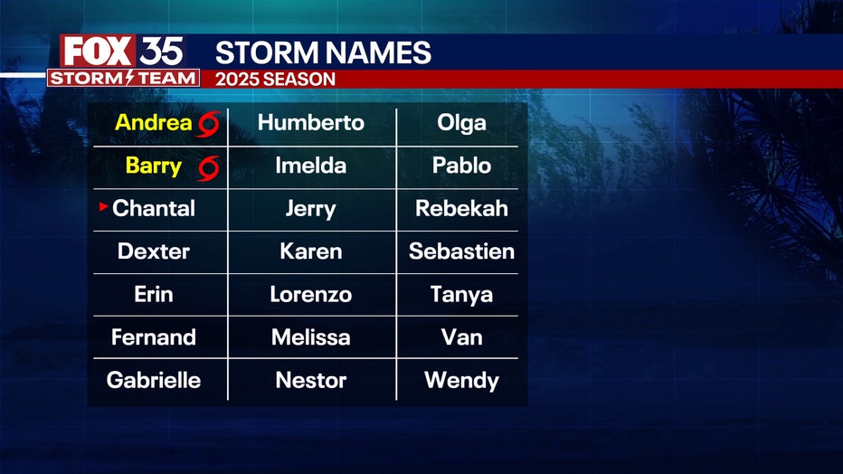
2025 Atlantic storm names
Dig deeper:
Whenever the next named storm develops in the Atlantic Basin, it will get the name Chantal.
The Source: This story was written based on information shared by the National Hurricane Center and the FOX 35 Storm Team.