

Strong Pacific El Niño could influence Atlantic conditions
ORLANDO, Fla. - Although events in the Pacific and Atlantic oceans can develop independently, scientists say the two basins can influence one another through changes in the atmosphere.
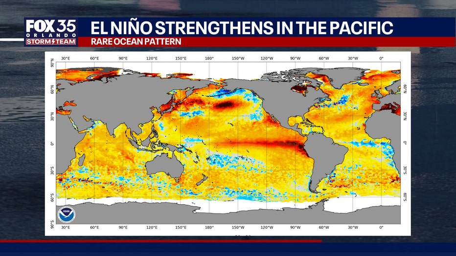
The current Pacific El Niño is driven by warmer-than-normal water along the equator. Those warmer waters can strengthen easterly winds over the Atlantic, increasing wave activity. A La Niña phase develops every few years in the Pacific Ocean, but similar conditions are much less common in the Atlantic.
Explainer: What are El Niño and La Niña?
Big picture view:
According to the National Oceanic and Atmospheric Administration, El Niño and La Niña are opposite phases of a naturally occurring climate pattern called the El Niño-Southern Oscillation, or ENSO.
The cycle begins in the tropical Pacific Ocean but can influence weather patterns around the world, including the United States and Florida.
"What happens in the Pacific Ocean impacts what happens in the atmosphere over the Atlantic Ocean and the ocean temperatures themselves," explained FOX 35 Storm Team Meteorologist Laurel Blanchard. "Events in both oceans can be generated independently, but each ocean can influence the other even with a continent in between them. There will be interaction through the atmosphere."
NOAA says the climate pattern typically shifts between El Niño, La Niña and a neutral phase every three to seven years on average.
What is El Niño?
El Niño is the warm phase. It occurs when sea surface temperatures in the central and eastern tropical Pacific become warmer than average and are accompanied by changes in atmospheric circulation and winds. Those ocean-atmosphere changes can alter storm tracks, temperatures and rainfall patterns across the globe.
"El Niño in the Pacific is created by warmer than normal temperatures in the water along the equator. That leads to an increase in easterly winds in the Atlantic, which triggers more wave activity," Blanchard said. "More waves can lead to cooler waters as waves stir up the cooler water below the surface, helping fuel a La Niña in the Atlantic."
NOAA notes that these are changes in probability, not guarantees.
"El Niño tends to have the biggest impact on winter weather in the U.S. It usually brings warmer, dry weather to the northern half of the country, while the southern half of the country, including Florida, experiences a wetter winter," Blanchard added.
What is La Niña?
La Niña is the cool phase of ENSO. It develops when sea surface temperatures in the central and eastern tropical Pacific are cooler than average, along with corresponding changes in atmospheric circulation. Like El Niño, La Niña can persist for months and influence weather patterns well beyond the Pacific Ocean.
During La Niña, the United States often experiences weather patterns that are generally opposite those seen during El Niño. NOAA says La Niña tends to favor drier conditions across the southern U.S., while parts of the northern U.S. are more likely to see cooler and wetter conditions. La Niña also can create conditions more favorable for the Atlantic hurricane activity by reducing vertical wind shear over parts of the Atlantic basin.
What is the biggest difference?
Dig deeper:
The primary difference is the temperature of the tropical Pacific Ocean:
El Niño: Warmer-than-average ocean temperatures.
La Niña: Cooler-than-average ocean temperatures.
Those opposite ocean temperature patterns change atmospheric circulation, which affects rainfall, temperatures and storm tracks around the world. Because ENSO influences probabilities rather than specific weather events, no two El Niño or La Niña episodes produce identical impacts.
Why do they matter?
NOAA considers ENSO one of Earth's most important climate patterns because it can affect seasonal weather months in advance. Its impacts can include changes in drought and flood risk, winter weather, agriculture, water supplies, wildfire conditions and Atlantic hurricane activity.
"While it’s too soon to say if we’ll see an Atlantic La Niña, we already know we’re seeing El Niño conditions in the Pacific. Very strong El Niño phases, like what we are expecting to see by September, are rare," Blanchard said.
The Source: This story was written based on information shared by the National Oceanic and Atmospheric Administration and the FOX 35 Storm Team.