

Orlando weather: Mostly dry tonight; showers possible late Sunday into Monday
Orlando Weather Forecast: Worst drought in 25 years and Daytona showers
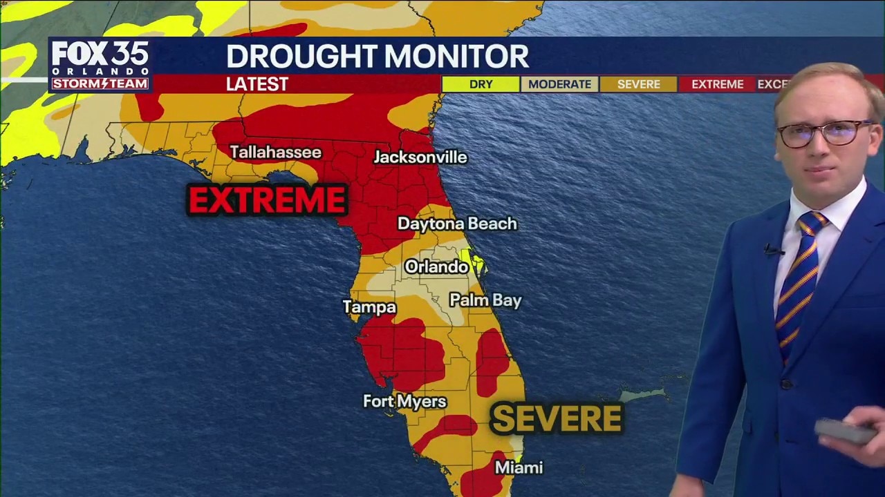
FOX 35 Storm Team Senior Meteorologist Noah Bergren is tracking extreme drought across Florida and some rain showers late day on Sunday at Daytona.
ORLANDO, Fla. - Mostly cloudy skies are expected this evening with a few passing rain showers before midnight.
Conditions will turn mainly dry overnight with mild temperatures.
What will the weather be like in Orlando this weekend?
What To Expect:
Low temperatures on Friday mooring will dip into the upper 40s to mid 50s for most of the region before warming up to near 80 degrees around Orlando.

Friday and Saturday are forecast to be mostly sunny and warmer, with highs in the upper 70s to low 80s and largely dry conditions.
What is the Daytona 500 forecast?
What To Expect:
Cloud cover increases Sunday, though the morning is expected to remain dry. A few light, passing showers are possible late in the day.

With the Daytona 500 taking place on Sunday, we're watching these rain chances and impacts closely. Winds will be gusting up to 30 mph Sunday, which may affect drivers on the track.

The trend appears to be that the bulk of the heaviest rain will arrive late Sunday evening and early Monday.
When is the next significant rainfall?
Looking Ahead:
Any significant rain or downpours are forecast to hold off until after midnight Monday. While a brief weather-related delay is possible Sunday evening, the race is expected to start and finish as scheduled.
Showers and thunderstorms are likely Monday morning through midday, with some storms potentially producing heavy rain, lightning and gusty winds.

Drier and much warmer weather is expected to return Tuesday and continue through the week, with temperatures climbing into the mid-80s by late week.
Despite the expected rainfall late Sunday into Monday, forecasters say it will not significantly ease drought conditions.
Worst drought since 2000
Big picture view:
Florida is experiencing its worst drought in over two decades.
A very high wildfire risk exists for several weeks to come because much rain will be needed to overcome this deficit.

Burn bans exist across several Central Florida counties, which are also experiencing water shortages in lakes and rivers.

Skie will start to clear on Tuesday and temperatures will warm back into the mid-80s by the end of next week.

The Source: This story was written with information from the FOX 35 Storm Team.