

Orlando weather: Near-record heat Saturday before sharp cooldown early next week
Orlando Weather Forecast: Extreme temperature swing in Florida; 90 to 20s
FOX 35 Storm Team Senior Meteorologist Noah Bergren is tracking record heat again Saturday and a major drop in temperature on the way for the early part of next week. Who may see Freeze Warnings and more.
ORLANDO, Fla. - Clear skies and unseasonably warm temperatures will continue through tonight across Central Florida, with a light breeze and overnight lows falling into the mid- to upper 50s.
Areas of patchy fog are expected to develop late, which could affect visibility during the early morning commute.
Saturday's high could break record
What To Expect:
Temperatures will continue to stay warm with a high on Saturday of 88 degrees. On Saturday we will be flirting with daily record highs (the Feb. 21 daily record high in Orlando was 88 degrees set back in 1989).

Temperatures will be soaring above average for the next few days. Temperatures on average for this time of year linger in the mid 70s.

Don't get too comfy in the heat, colder temperatures are on the heels of this warm-up.

Sunday expect showers
What To Expect:
A cold front sweeps through Central Florida Sunday, bringing the chance of showers. Although this front will bring MUCH needed rain, it will also bring another cold snap.

Temperatures will drop — still above average — but cool compared to the temperatures on Saturday. Sunday temperatures will cool down into the upper 70s and then really cool down into the 40s Monday morning and low 60s on Monday afternoon.
Winds both Sunday, as the front moves through, and Monday will be gusty with winds 20–25 MPH. With that in mind, Monday AM temps will feel like the 30s in Orlando and the 20s in Ocala and Gainesville.
Temperatures plunge next week
Looking Ahead:
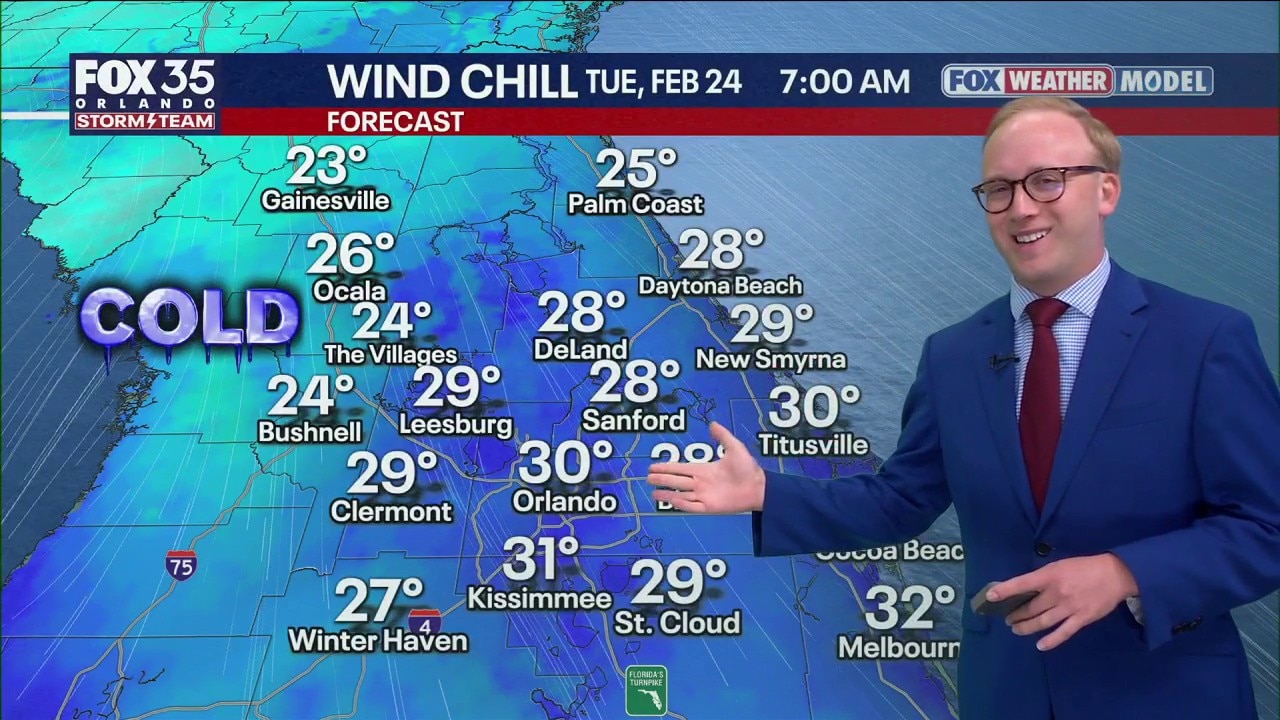
Temperatures will still feel like the 30s on Tuesday morning as temperatures stay gusty.

Freeze Warnings possible for northern counties Tuesday morning next week (Ocala, Gainesville, Palm Coast, etc).


The 60s degree highs stick around through Tuesday afternoon and will slowly rebound back into the low 70s by Wednesday afternoon.
The Source: This story was written with information from the FOX 35 Storm Team.