

Orlando weather: West Florida faces daily downpours, east stays mostly dry with scattered storms

Orlando Weather Forecast PM: June 11th, 2025
FOX 35 Storm Team Meteorologist Noah Bergren is tracking afternoon and evening thunderstorms moving more into the west coast of FL over the next few days.
ORLANDO, Fla. - A line of strong to potentially severe thunderstorms is expected to die down late Wednesday.
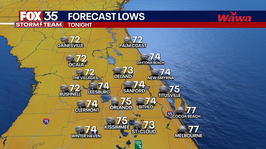
What will the weather look like tonight?
What to expect:
Lingering storms along Florida's western coast will dissipate on Wednesday evening. Meanwhile, much of Central and Eastern Florida, including Orlando and the Atlantic Coast, will remain largely hot and dry with only isolated storm chances.
Lows will drop into the mid-70s.
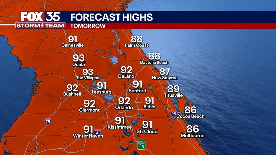
What will the weather look like tomorrow?
What to expect:
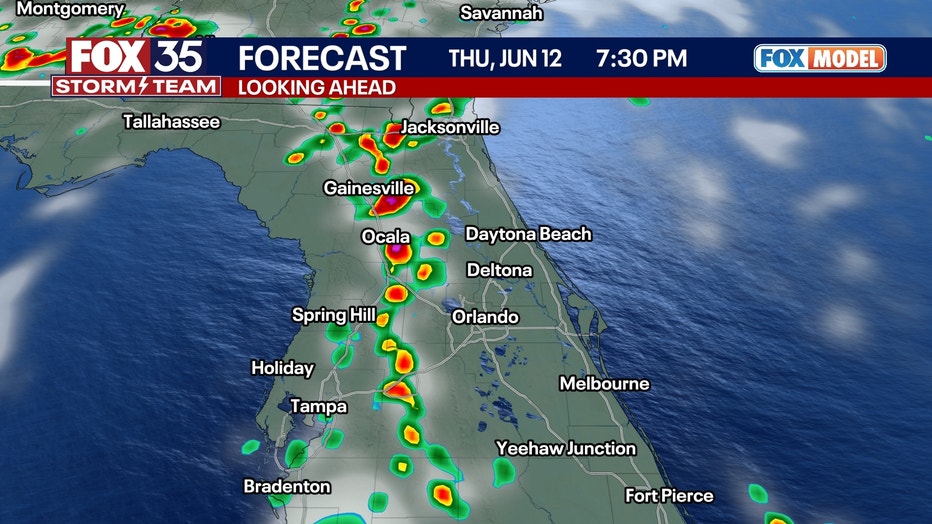
Storms continue to target Florida’s western interior and Gulf Coast areas, particularly along the I-75 corridor, from The Villages through Ocala and down to Tampa.
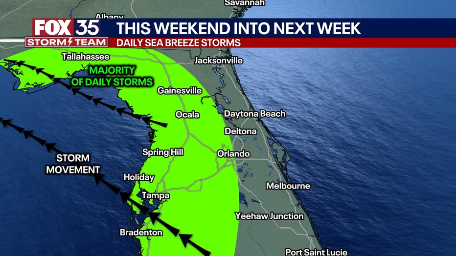
While a few isolated thunderstorms could develop early to mid-afternoon around the Orlando metro, the greater threat for organized storms will once again target areas west of Orlando — along I-75 and toward the Gulf Coast, including Tampa and St. Petersburg.
Heat remains the dominant weather feature, with inland highs climbing between 90 and 94 degrees. Afternoon heat index values could reach between 100 and 104.
This shift in the storm track marks a noticeable change in the pattern, with the majority of afternoon storms now favoring the west coast and fewer impacts for Orlando and the Atlantic side.
Looking ahead:
Rain and thunderstorm chances will remain highest from Tampa to Sarasota, Fort Myers and the I-75 corridor through Sunday. While isolated storms can't be ruled out around Orlando or along the I-4 corridor, those areas are likely to stay mostly dry compared to regions farther west.
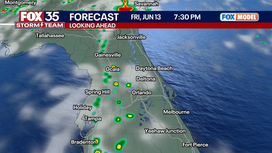
"Rain chances continue to favor the west coast, Tampa, Sarasota, Ft. Myers, and I-75 corridor. Yes, obviously a t-storm here or there is possible in the Orlando area. Chances are low compared to the west coast, Ocala, Gainesville, and The Villages," said FOX 35 Storm Team Meteorologist Noah Bergren. "This is valid for Friday, Saturday, and Sunday."
Communities along the I-95 corridor and Atlantic beaches, including Daytona Beach and Melbourne, are also likely to see minimal rainfall during this period.
Tracking the Tropics
Tropical activity remains quiet in the Atlantic basin. However, forecasters expect continued high activity in the eastern Pacific over the next seven days as hurricane season ramps up.
Orlando 7-Day Weather Forecast

FOX 35 Storm Tracker Radar
Track live when storms move across your area using the FOX 35 Storm Tracker Radar below.

More radar maps from FOX 35 Storm Tracker Radar
- Brevard County
- Flagler County
- Lake County
- Marion County
- Osceola County
- Orange County
- Polk County
- Seminole County
- Sumter County
- Volusia County
- U.S./National Radar
STAY CONNECTED WITH FOX 35 ORLANDO:
- Download the FOX Local app for breaking news alerts, the latest news headlines
- Download the FOX 35 Storm Team Weather app for weather alerts & radar
- Sign up for FOX 35's daily newsletter for the latest morning headlines
- FOX Local: Stream FOX 35 newscasts, FOX 35 News+, Central Florida Eats on your smart TV
The Source: This story was written based on information shared by the FOX 35 Storm Team on June 11, 2025.