

Orlando weather: Heavy rainfall, 'pockets' of flooding, possible hail
Orlando PM Weather Forecast: Heavy rain, localized flooding
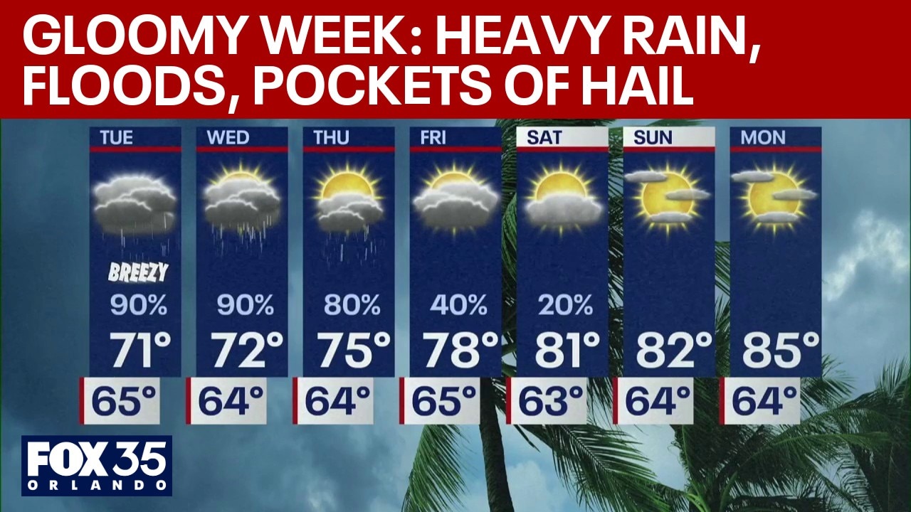
Heavy rain is expected throughout the Central Florida area this week, with some areas expected to get at least seven inches. Despite this, due to the ongoing drought, it's possible many areas won't flood.
ORLANDO, Fla. - Central Florida is bracing for a rainy week as rain, gusty winds and dangerous beach conditions are expected. While rain is a welcome break from the ongoing drought, some areas might experience flooding.
Tonight: Tracking numerous storms
Numerous showers and storms are expected to persist through the evening and overnight hours. Residents should prepare for frequent lightning, gusty winds, and bursts of very heavy rain.

While the overall severe weather risk remains slim, meteorologists are closely monitoring the radar for "storm collisions." If two individual storm cells merge or "ram" into each other, it can induce a brief window of rotation, potentially leading to isolated severe weather.
FOX 35's Noah Bergren said though it's not expected that rain will persist every hour from tonight until Thursday, those in the area should be aware of heavy rain during certain times in the week.
"When it does rain, it's a summer preview. It's torrential rain," Bergren said.

Tuesday & Wednesday: Highest chance of rain
The next 48 hours will feature the highest rain chances, particularly for areas east of Orlando and along the entire I-95 corridor.
Tuesday: Expect an overcast day with waves of showers and storms arriving at any time—not just during the typical afternoon window. Torrential downpours are likely throughout the day.
Wednesday: Clouds will remain thick with more "focused" storm activity. Forecasters are specifically watching for a narrow, intense band of heavy rain that could form late Wednesday into Thursday morning. It is possible late Wednesday into Thursday morning that a locally narrow, but intense band of heavy rain forms somewhere that could dump significant rain totals and localized flooding.

Bergren also predicted the possibility of some hail.
Additionally, the chances of a funnel cloud are low, but not zero.
The silver lining: Drought relief
Despite the travel headaches and beach closures, this system is providing much-needed "beneficial rain." Parts of the I-95 corridor and the beaches could see total accumulations exceeding six inches by Thursday evening. Inland areas will see lower, yet still significant, totals that will help combat the region’s severe drought levels.

Looking ahead: A beautiful weekend
The rain will begin to wane Thursday afternoon as the system finally pulls away.
Friday – Sunday: Central Florida will clear out just in time for the weekend. Expect dry conditions and a return to the 80s, providing a perfect window for outdoor plans after a soggy start to April.
The Source: Information in this story was gathered from FOX 35's Noah Bergren.