

Orlando weather: Hot, humid days continue with slight midweek storm increase
ORLANDO, Fla. - Here's a look at what to expect from the weather today, tomorrow and through the rest of the week.
What will the weather look like tonight?
What To Expect:
Tonight you can expect a handful of thundershowers through the evening. Not a lot of activity.
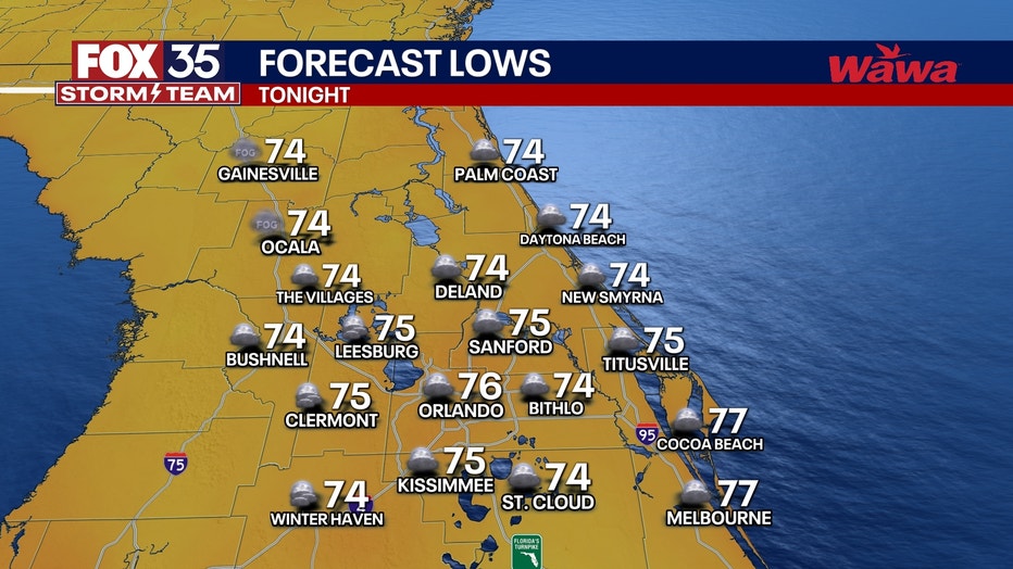
Temperatures are expected to fall into the mid 70s.
What will the weather look like tomorrow?
What's next:
Tomorrow will be hot again with highs in the mid 90s and heat index values near 100-103°F in the afternoon.

Low rain chances again with only limited PM t-showers.
What will the weather look like for the rest of the week?
Dig deeper:
Rain chances come up slightly on Thursday and Friday (50-60%) with better coverage of storms and more focused around central FL.
This weekend, rain chances taper back down slightly to 30-40% and it will be mostly sunny.
Highs 92-95 degrees in inland areas from Thursday through the foreseeable future.
The tropical Atlantic remains quiet and will stay so for a while.
FOX 35 Storm Tracker Radar and Live Weather Cameras
Track live when storms move across your area using the FOX 35 Storm Tracker Radar below. You can also watch as heavy rain moves across Central Florida on our Live Weather Cameras' page here.

More radar maps from FOX 35 Storm Tracker Radar
- Brevard County
- Flagler County
- Lake County
- Marion County
- Osceola County
- Orange County
- Polk County
- Seminole County
- Sumter County
- Volusia County
STAY CONNECTED WITH FOX 35 ORLANDO:
- Download the FOX Local app for breaking news alerts, the latest news headlines
- Download the FOX 35 Storm Team Weather app for weather alerts & radar
- Sign up for FOX 35's daily newsletter for the latest morning headlines
- FOX Local: Stream FOX 35 newscasts, FOX 35 News+, Central Florida Eats on your smart TV
The Source: This story was written based on information shared by the FOX 35 Storm Team on June 17, 2025.