

Orlando weather: Central Florida braces for dangerous heat wave, hottest weekend of summer

Orlando Weather Forecast PM: July 25, 2025
FOX 35 Storm Team Senior Meteorologist Noah Bergren is tracking one of the hottest stretches of the season so far.
ORLANDO, Fla. - Central Florida is bracing for a dangerous heat wave, with forecasters warning residents to prepare for one of the hottest weekends of the summer.
Here's what to expect from the weather this afternoon and evening, as well as a look at what comes next this weekend, and a sneak peek into next week.
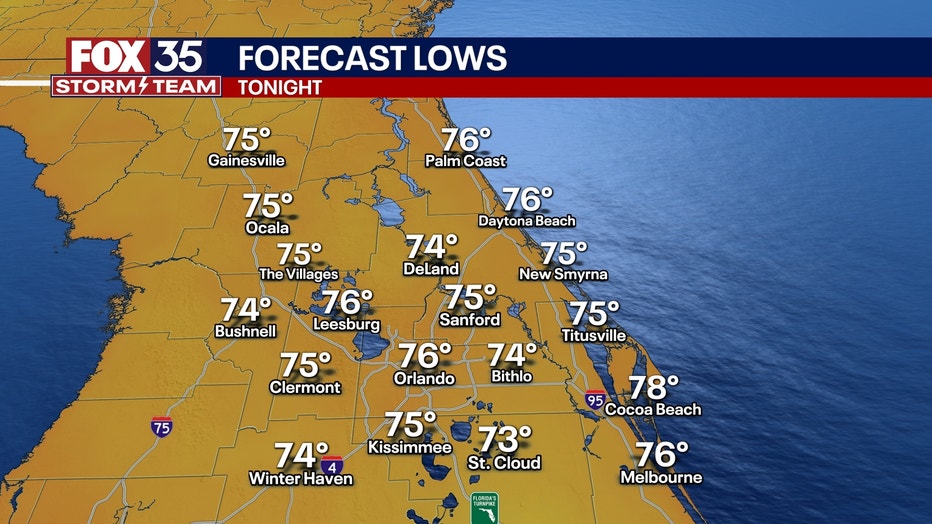
What will the weather look like tonight?
What to expect:
Very scattered showers will pop up sporadically across the region heading into this evening.
However, any showers that do pop up will quiet down after sunset.
CLICK TO DOWNLOAD THE FOX LOCAL APP
Mainly clear skies are on tap through the overnight hours, and temperatures will fall into the mid-70s and stay mild and muggy.
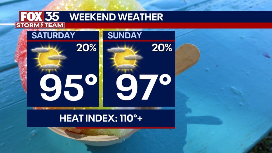
What will the weather look like this weekend?
What's next:
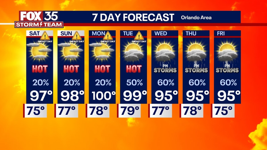
Rain chances stay low for the weekend as dry air pushes into the region.
But, these will likely be the hottest temperatures we've felt so far this summer.
Temperatures will sizzle back in the mid-90s for the weekend and early next week. The humidity will really make things feel hot, with heat indexes reaching levels as high as 110°+. Heat advisories will most likely be issued for this weekend and possibly early parts of next week.
You will also notice the skies are a little hazy because of another wave of Saharan Dust sweeping over the region.
Stay cool, stay hydrated and listen to your body! Heat exhaustion can set in quickly, so take it easy!
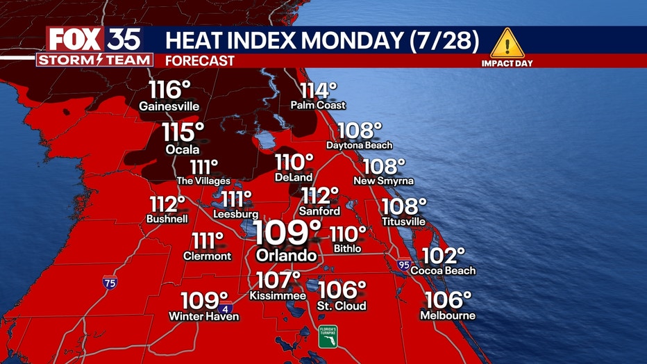
What will the weather look like next week?
Looking Ahead:
The heat really kicks in on Monday, as we will be expecting the hottest day of 2025 so far.
Highs will be in the upper-90s, and, with the humidity, it will feel like about 110°+.
SIGN-UP FOR FOX 35'S BREAKING NEWS, DAILY NEWS NEWSLETTERS
On Tuesday, the heat dome that has been bringing us the intense heat this weekend will move off to the west, and we will see the return of our daily afternoon Seabreeze storms.
Tracking the tropics
Dig deeper:
We are continuing to monitor a very small area of interest that could still develop into a tropical system.
Although there will be zero impacts on Florida, the moisture that originally came from the chance of tropical development two weeks ago was once again pushed through the Sunhine State, bringing us the rain we saw during this past week. This will bring once again lots of heavy rainfall to the Gulf coast of Texas and Louisiana.
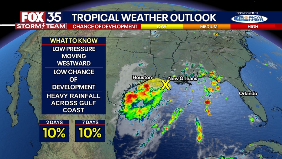
There is a 10% chance of development over the next 48 hours and within the next seven days.
We are also keeping an eye on some tropical waves along the Atlantic, but with the dust in the atmosphere, it should keep things quiet for at least a little longer.
The 2025 Atlantic Hurricane Season runs from July 1 through Nov. 30.
The Source: This story was written based on information shared by the FOX 35 Storm Team on July 25, 2025.