

Orlando weather: Afternoon showers, storms on the way ahead of Weather Impact Day
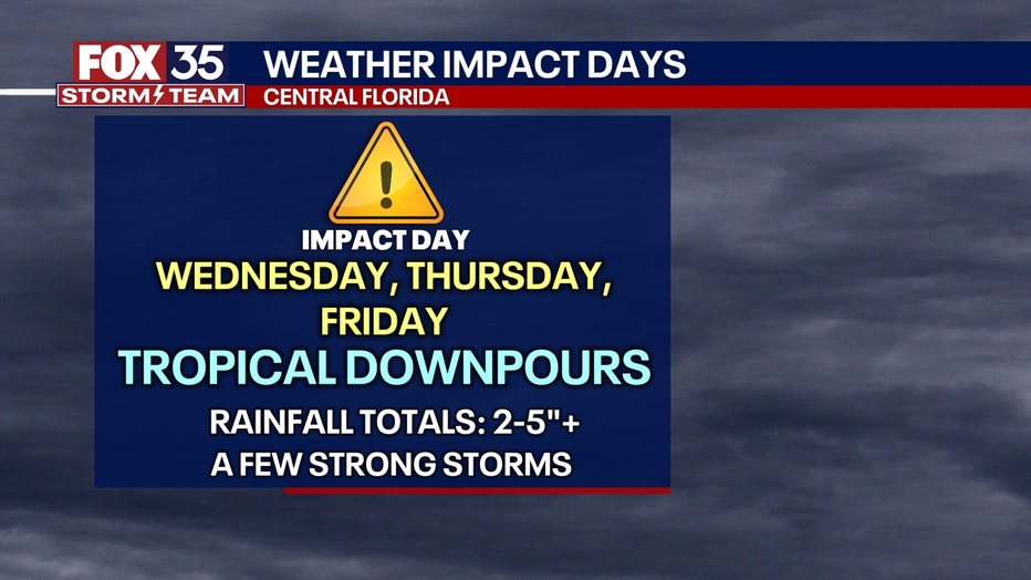
ORLANDO, Fla. - Storms across Central Florida will dissipate as we head into the overnight hours with a few pop-up showers. The FOX 35 Storm Team has labeled Wednesday as a Weather Impact Day as we will begin to experience tropical moisture from a low pressure system that is expected to stall over Florida.
Here's a look at what to expect from the weather tonight, tomorrow and heading into the Fourth of July weekend.
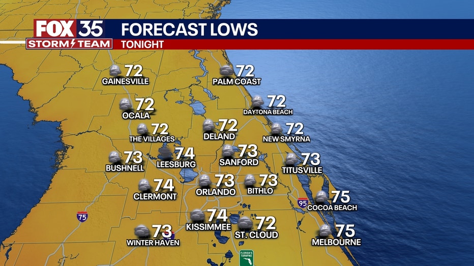
What will the weather look like tonight?
What To Expect:
Things will be relatively calm overnight with the possibility of some scattered showers. Low temperatures drops into the 70s.
CLICK TO DOWNLOAD THE FOX LOCAL APP
FOX 35 Storm Team Impact Days on the way
What's next:
Tropical moisture filters into Central Florida as we head into the end of the week.
Winds will be shifting and moving in from the south, ushering in a more humid air mass ripe with moisture.
SIGN-UP FOR FOX 35'S BREAKING NEWS, DAILY NEWS NEWSLETTERS
A weakening cold front will gradually sink into the region. This will also help to bring an increase in our rain chances as the front slows down and parks itself across the peninsula.
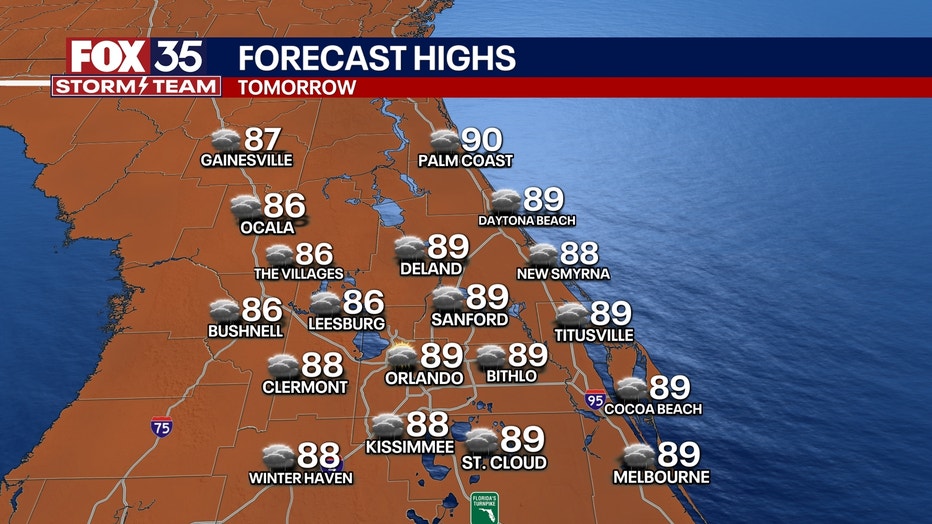
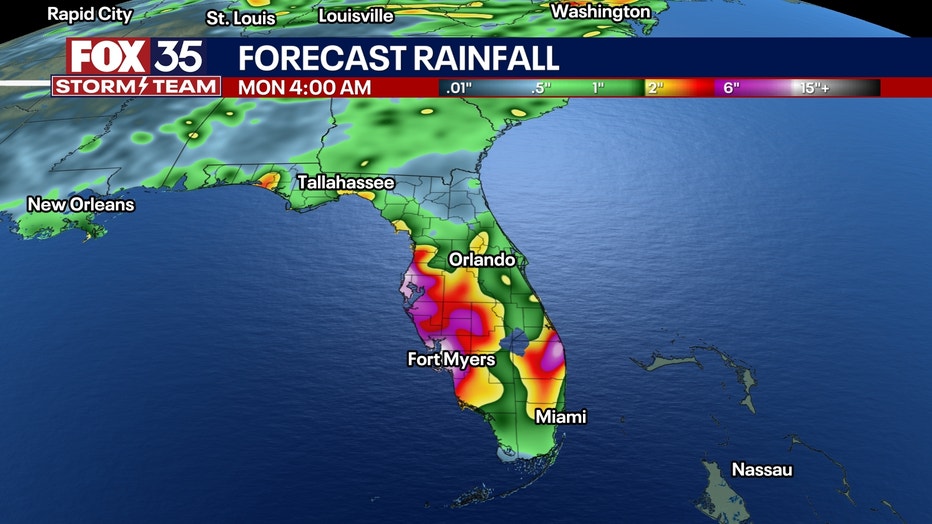
All of these factors will lead to multiple rounds of heavy rainfall. Low-lying and flood-prone areas should stay close to the forecast as 2 to 4 inches of rain will be possible across Central Florida with a few isolated areas closer to the 5-inch mark.
The best chances of rain will be during the peak heating of the day as the Atlantic and Gulf coast sea-breezes come into play. Better chances of dry time will take place in the morning hours.
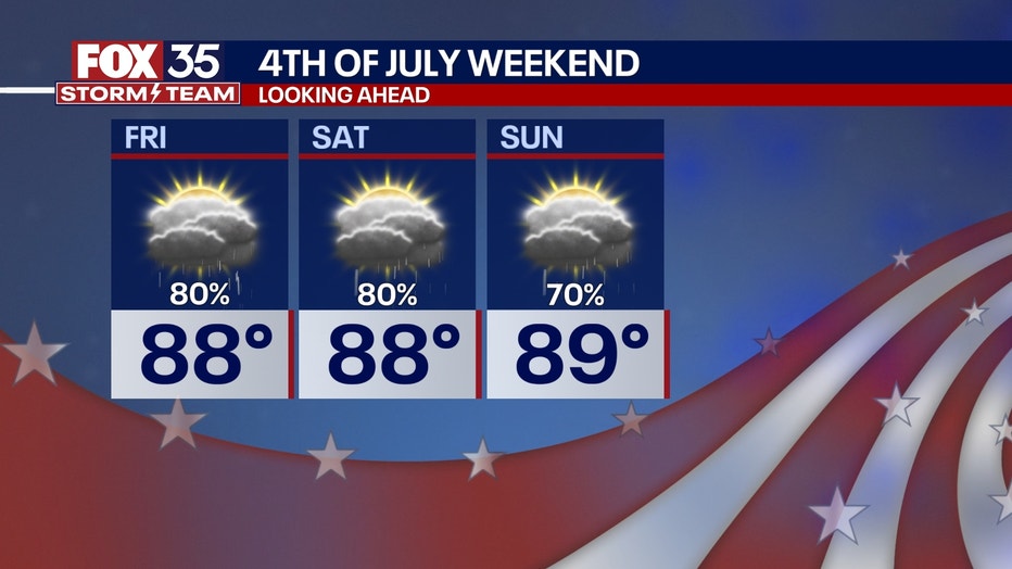
What will the weather look like for the Fourth of July weekend?
Dig deeper:
The waves of heavy rain will continue this weekend.
Around and after lunchtime will be the timing of the best chances of rain, along with the heaviest.
RELATED: How much rain will the Orlando area get this week? Here's a look
If you have outdoor plans for the Fourth of July or the rest of the holiday weekend, be sure to have a back-up in case things get rained out.
Tropics update
Big picture view:
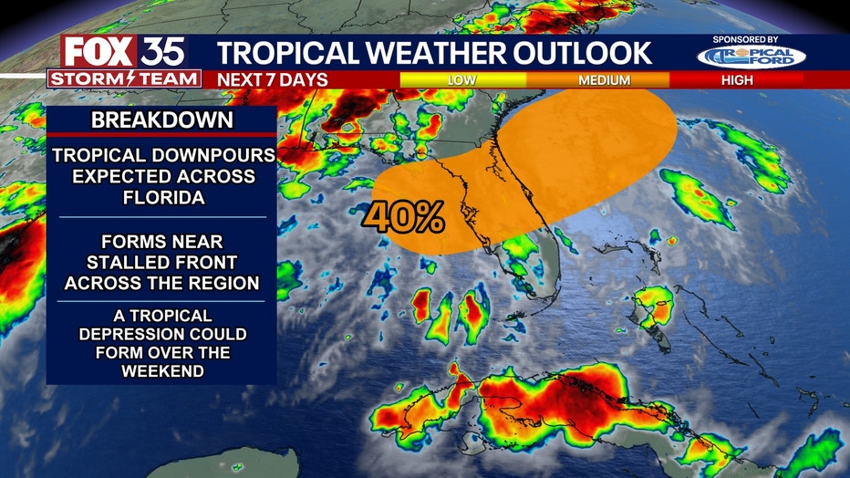
The National Hurricane Center (NHC) is still outlining an area of potential tropical development (now 40%) that stretches from the Gulf, through Central Florida and into the Atlantic waters.
An area of low pressure looks to form along the remnants of a stationary front that will be draped across Central Florida by the end of this week. This area of low pressure could form either over the Gulf or Atlantic waters, with models favoring a Gulf system set-up at this time.
RELATED: Florida tropics update: Potential disturbance brings threats of heavy rain, thunderstorms
There's a chance a tropical depression may form, but regardless if one forms or not, heavy rainfall is likely. With plenty of tropical moisture in place, a lot of rain will fall over a short period of time. The best chances of rain will be during the afternoon, with the peak heating of the day starting Wednesday and lasting into at least Saturday. So far, areas along the Florida Gulf coast, specifically near Tampa through the Big Bend region, will be where the highest rainfall totals will be. This is where more than 6 inches of rain could fall.
FOX 35 Storm Tracker Radar and Live Weather Cameras
Track live when storms move across your area using the FOX 35 Storm Tracker Radar below. You can also watch as heavy rain moves across Central Florida on our Live Weather Cameras' page here.

More radar maps from FOX 35 Storm Tracker Radar
- Brevard County
- Flagler County
- Lake County
- Marion County
- Osceola County
- Orange County
- Polk County
- Seminole County
- Sumter County
- Volusia County
- U.S./National Radar
The Source: This story was written based on information shared by the FOX 35 Storm Team on July 1, 2025.