

Orlando breaks heat records, hits 90 degrees for first time this year
Orlando PM Weather: Even Warmer on Wednesday but rain on the way
Central Florida will be felt the heat today and will be in for another round of it tomorrow. It will be a dry and hot Wednesday with temperatures possibly or tying daily record highs. But rain is on the way. FOX 35 Storm Team Meteorologist Laurel Blanchard takes a look at the forecast.
ORLANDO, Fla. - Orlando reached 90 degrees on Tuesday, March 10, marking the first 90-degree day of the year. It also tied the 108-year-old daily heat record set back in 1918.
Records were also tied or broken in Gainesville, Leesburg, and Sanford.
Record-tying or record-breaking heat
- Leesburg set a new daily heat record on Tuesday, reaching 88 degrees. The previous record was 87, set in 1974.
- Sanford hit 90 degrees, tying its heat record also set in 1974.
- Gainesville reached 91 degrees, breaking its daily heat record of 90 degrees, set in 1974.
Tonight's forecast
What To Expect:
Temperatures will be hot through the rest of the afternoon and evening. Along I-95 reaching the low 90s, inland areas reaching the upper 80s, and highs in the mid 80s along the coast. This heat will challenge records today and Wednesday.
There is the chance of a pop-up shower or two through the late afternoon and early evening, but by sunset the showers will fizzle out. Temperatures tonight will stay mild and conditions muggy. Temperatures tonight will dip into the mid 60s. There will be another chance for patchy fog tomorrow morning, so be careful on the AM commute.
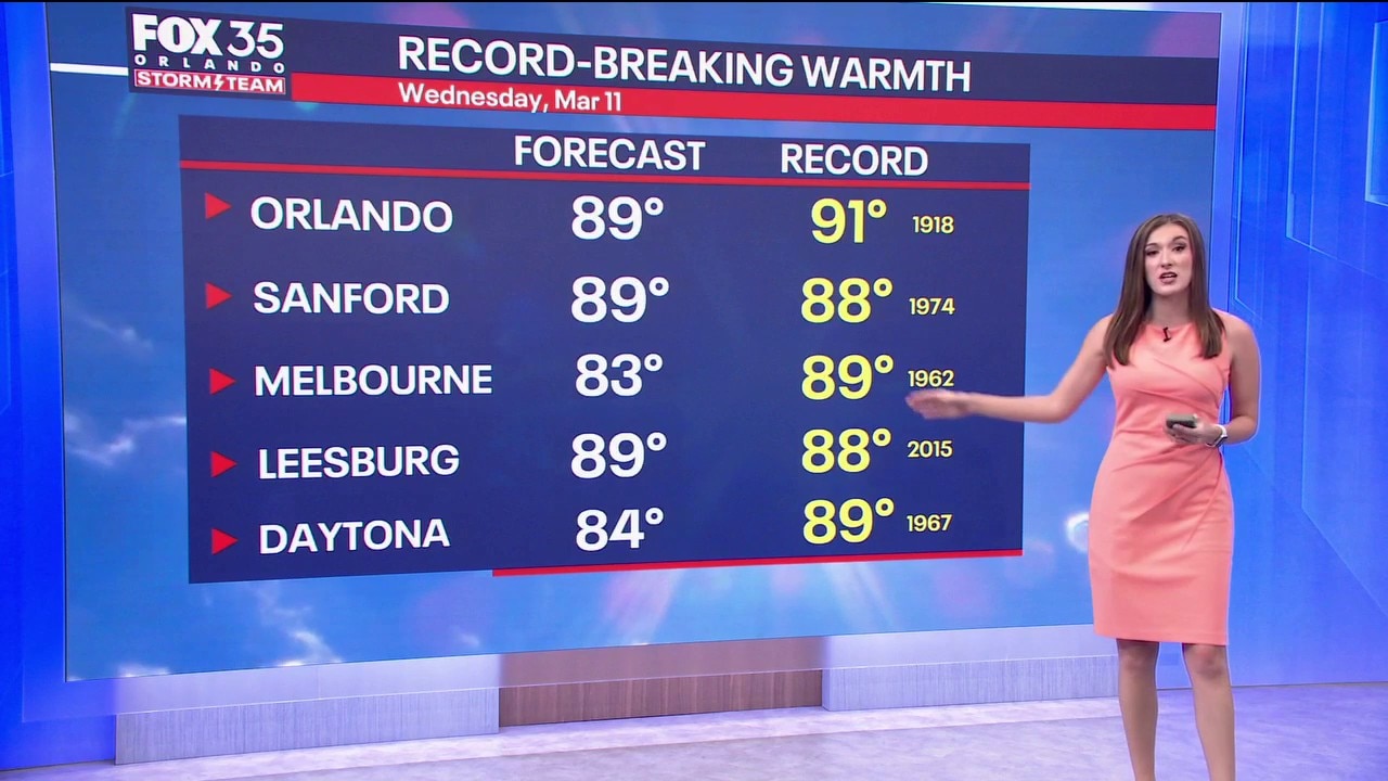
Wednesday's forecast: Heat records in jeopardy
Wednesday will be another hot day, where daily heat records could be tied or broken. Highs will be unseasonably warm with most spots in the upper 80s, and a few in the 90s.
Wednesday night, it will be breezy with clear skies. Temperatures will drop to the upper 60s.

Future Forecast: Humid with increasing rain chances
Looking Ahead:
On Thursday, the weather changes from hot and humid to rain, just as Spring Break begins for many in Florida. A cold front will increase rain chances on Thursday. Temperatures will be cooler.
That front moves out on Friday, though there is a chance for some showers and thunderstorms. Rain chances stick around through the weekend.
Next week, a cold front brings an increased chance for rain and showers.
The Source: This story was written with information from the FOX 35 Storm Team.