

Orlando weather: High storm chances this week for Central Florida

Orlando PM Weather Update: August 4, 2025
The workweek is starting off a bit unsettled. Meteorologist T.J. Springer has the details on our storms chances this week and what's churning in the tropics.
ORLANDO, Fla. - Summer’s full intensity is on display today across the Central Florida region. Here's what we know about this week's forecast.
What will the weather look like tonight?
What To Expect:
Storms gradually wind down overnight with mostly cloudy overnight with a lingering shower possible. It will be muggy with lows around 77 degrees.

What will the weather look like on Tuesday?
What to expect:
A ridge of high pressure has broken down some, but it's still looking like we'll get some real heat Tuesday afternoon. Highs look to jump back into the mid-90s and feel like temps up close to 108 degrees. This is the minimum for a Heat Advisory which is possible once again across the region.

The heat and humidity will help spark more storms during the afternoon and evening as the sea breeze shifts inland. A couple of stronger storms are possible with all of that instability. Gusty winds would be the main concern, as well as frequent lightning in the strongest of storms.

CLICK TO DOWNLOAD THE FOX LOCAL APP
What will the weather look like for the remainder of the week?
Looking ahead:
We are officially in the peak of the rainy season, and this week proves it! Higher storm chances every afternoon, with widespread downpours and lightning a daily risk through at least Friday. Highs will stay in the low 90s, and overnight lows in the upper 70s.

Tracking the Tropics
Dig deeper:
There are now three areas of interest in the Atlantic that the Storm Team is monitoring.
Tropical Storm Dexter is continuing to work out to sea which will thankfully not bring any major impacts to the U.S. It'll still likely make for some rougher surf along the East Coast Beaches and potentially a higher risk for rip currents.

The other areas we're watching closely are in the far Western Atlantic and deeper in the tropics, across the Main Development Region. There's a 30% chance of development over the next seven days just off the SE Atlantic Coast. This is where we still have this stalled frontal boundary.
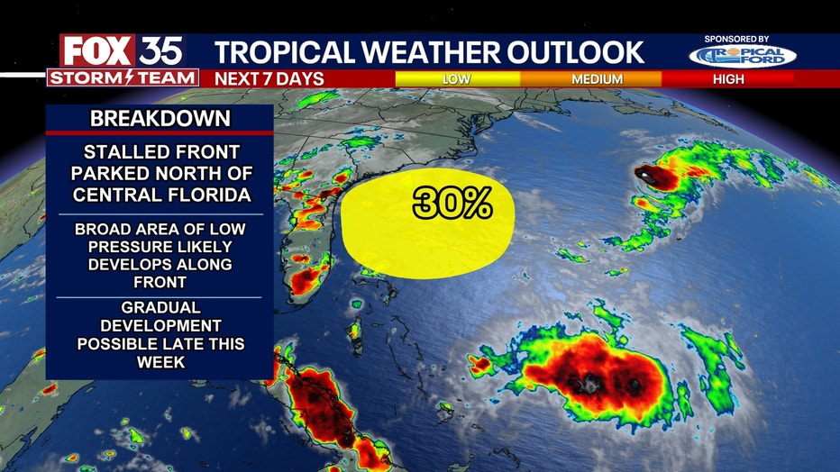
That boundary along with some "energy" aloft could allow a broad area of low pressure to form. Where it is in relation to the Bermuda High could actually allow it to move closer to Florida and keep our rain chances elevated. It'll be something we are watching.
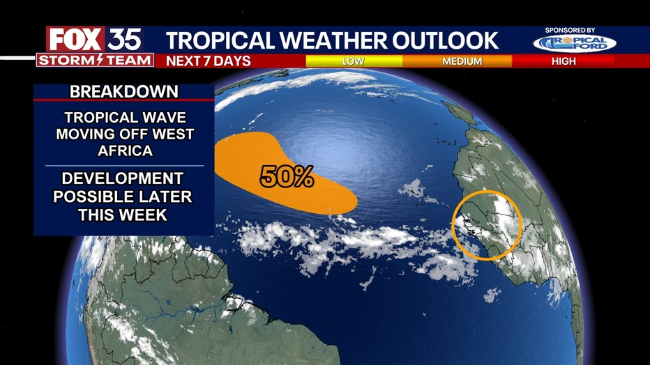
The other area of interest is much farther from Florida. A wave coming off the West African Coast now has a 50% chance of development. This will move over some real warmth in the Atlantic and it'll also not have as much dust inhibiting it.
Longer-range data continues to indicate at least the potential for another tropical storm out of this. It all depends on the ridge of high pressure in the Atlantic and the strength on where it goes as it could get pulled back out to sea or possibly move closer to the Caribbean.
Things can change fast this time of year, so don't let your guard down. Did you know that during the 2024 hurricane season, 10 of the 11 hurricanes formed AFTER July?
SIGN-UP FOR FOX 35'S BREAKING NEWS, DAILY NEWS NEWSLETTERS
The Source: This story was written based on information shared by the FOX 35 Storm Team on August 4, 2025.