

Orlando weather: Daily storm chances persist through the week

Orlando Weather Forecast: July 14, 2025
FOX's 35 Storm Team Meteorologist Brooks Garner has a look at the forecasts.
What will the weather look like today?
ORLANDO, Fla. - A few hit and miss showers are possible this morning, but higher chances of heavy downpours and storms are on the way this afternoon. A few isolated strong storms are possible during this time as well, with winds gusts of 50 mph+, frequent lightning, and torrential downpours. The SPC has placed nearly all of Central Florida under a level 1 out of 5 risk of severe storms. With tropical moisture at play, when it rains it will pour.
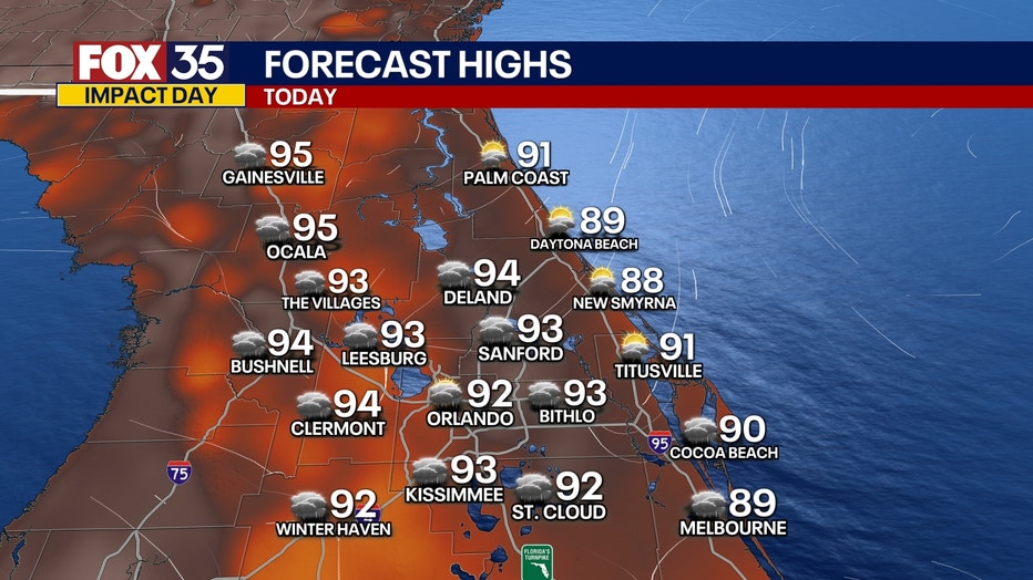
This could lead to ponding on roadways and flooding across low-lying and flood prone areas. That being said, it won't rain all day as there will be breaks in the active weather. During these breaks, it will be very hot and humid. Highs will climb into the low and mid 90s with feels-like temperatures in the range of 100°-107°.
A few lingering showers and storm are possible tonight. After midnight, the majority of these will steadily fade and clear out. We remain warm and muggy as morning lows fall into the mid to upper 70s.
What will the weather look like tommorow?
Additional rounds of heavy rain and storms are on the way for Tuesday across Central Florida. This will be due to an area of low pressure trekking across the peninsula over the next 24-48 hours. This means repeated rounds of scattered downpours and thunderstorms, with the risk of a few isolated strong storms. The main impacts include gusty winds, torrential downpours, and frequent lightning. While it won't rain all day, there is the chance of rain all day. Plus, when it rai
ns it will pour. Many areas could pick up around 1-3"+ of rain by Wednesday morning.
What will the weather be like for the week?
Soggy and unsettled weather will continue Wednesday into the weekend. Plan for daily rounds of afternoon showers and storms as a more July-like pattern takes shape. Temperatures will be seasonable, if not a few degrees above normal, with highs around the low to mid 90s.
Tracking the Tropics:
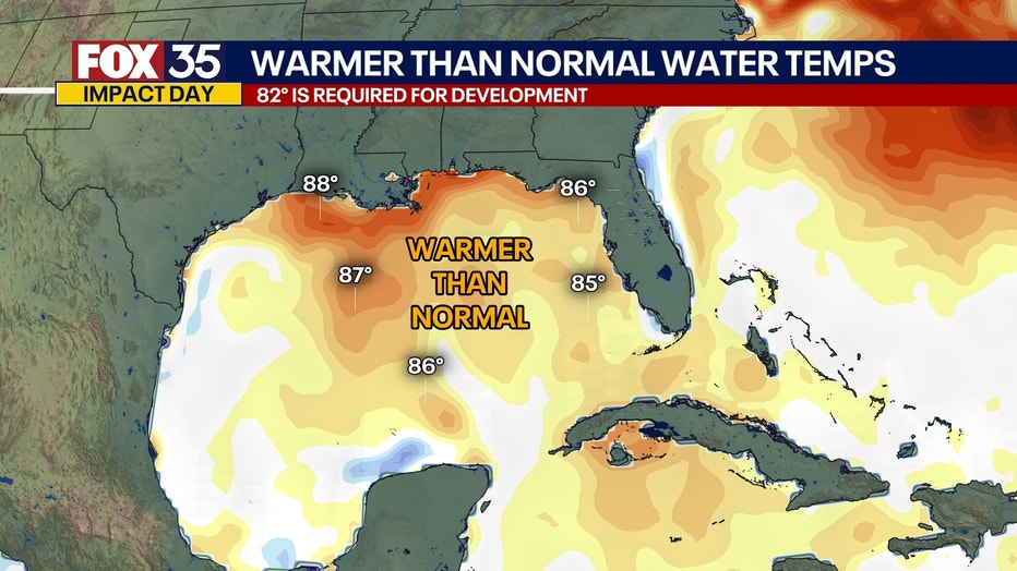
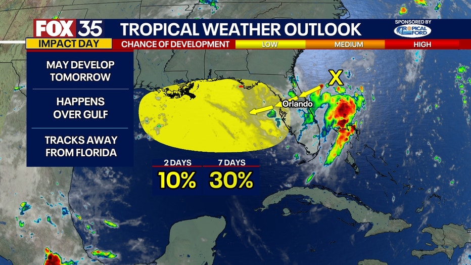
A non-tropical area of low pressure has formed off the southeastern coast of the US. This area of low pressure will gradually move west and over the Florida peninsula over the next 24-48 hours. As it does so, it will bring multiple rounds of heavy rain and storms to the region today and tomorrow, leading to rainfall totals as high as 2-4" for some. As it enters the Gulf, further tropical development is likely as it encounters a better environment, especially some very warm ocean waters. How strong it gets once it reaches the Gulf will be something we continue to monitor in the coming days. The NHC has outlined this area with a 30% chance of tropical development over the next 7 days and a 10% chance over the next 48 hours.
The Source: This story was written based on information shared by the FOX 35 Storm Team on July 14, 2025.