

Florida remains in forecast cone of what could become Tropical Storm Isaias

ORLANDO, Fla. - The National Hurricane Center (NHC) is issuing tropical storm advisories on Potential Tropical Cyclone Nine, a disturbance about 385 miles east-southeast of San Juan, Puerto Rico.
As of 5:00 a.m. Wednesday, the area of showers and storms was moving west-northwest at 23 mph.
Maximum sustained winds are near 45 mph with higher gusts. Some strengthening is expected, and the system is forecast to become Tropical Storm Isaias by 2:00 p.m. Wednesday. This would be the 9th named storm of the 2020 Atlantic hurricane season.
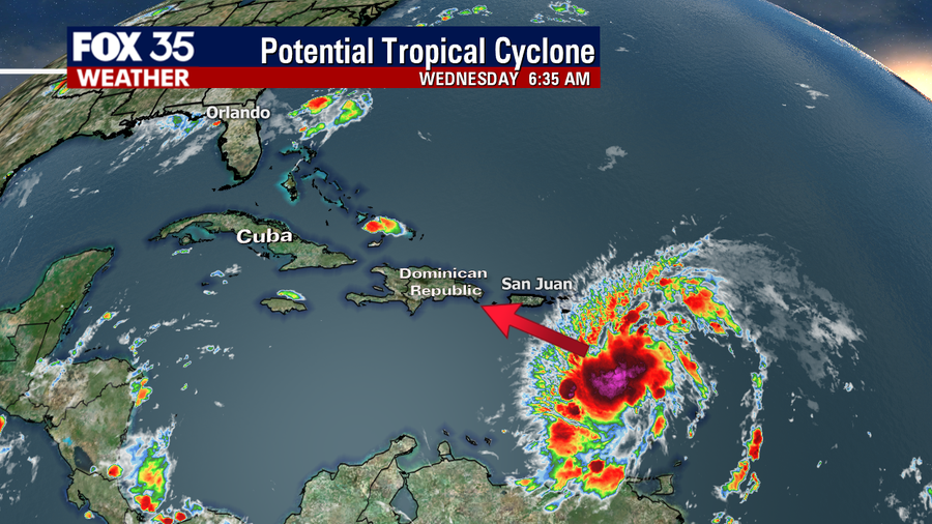

On the forecast track, the center will move near or over the Virgin Islands and Puerto Rico tonight, over Hispaniola on Thursday, reaching the southeastern Bahamas on Friday.
Florida remains within the cone of uncertainty.

The storm will produce heavy rains and potentially life-threatening flash flooding and mudslides across the northern Leeward Islands, the Virgin Islands, and Puerto Rico.


Tropical Storm Warnings are in effect for these areas, including the Dominican Republic and the north coast of Haiti.
TRACK THE TROPICS: Visit the FOX 35 Orlando Hurricane Center for the latest in the tropics, including daily updates, live radar, and severe weather alerts.
The government of the Bahamas has issued a Tropical Storm Watch for the southeastern Bahamas.
STAY PREPARED: Get all you need to know about the 2020 Atlantic hurricane season with the FOX 35 Orlando Hurricane Guide
The 2020 Atlantic hurricane season, which officially began June 1, has since May 16 produced seven tropical storms and one hurricane. Hurricane Hanna on Saturday became the first hurricane to make landfall in Texas in July since 2008.

Track the Tropics on the FOX 35 Weather App
FOX 35 meteorologist Allison Gargaro tracks the tropics on the FOX 35 weather app.
Tune in to FOX 35 Orlando for the latest weather updates and severe weather alerts.