

Invest 95L forms near Bermuda: Will it impact Florida?
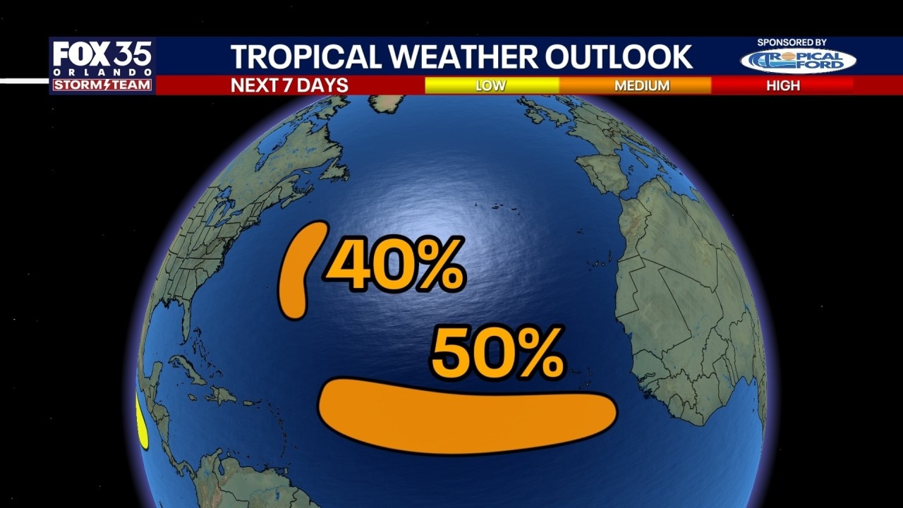
National Hurricane Center tracking 2 potential tropical depressions in Atlantic
The National Hurricane Center is monitoring two Atlantic disturbances, including Invest 95L near Bermuda and a tropical wave moving off the coast of West Africa. Invest 95L is expected to remain disorganized and stay over the open ocean due to a high-pressure ridge, posing no threat to Florida or the U.S. mainland.
ORLANDO, Fla. - FOX 35 is watching multiple waves that we're watching in the Atlantic Basin with the potential of being designated as a tropical depression, including one that will move off the coast of West Africa early this week.
Tracking: 2 potential tropical depressions
According to the National Hurricane Center, two disturbances have the potential of becoming a tropical depression this week:
- A system southeast of Bermuda has a 40% chance of developing into a tropical depression in two days.
- A tropical Atlantic system has a 50% chance of developing into a tropical depression by mid to late-week.
Aug 23 early afternoon- Watching 2 areas that could become tropical depressions (TDs) this week. The system SE of Bermuda (#AL95) has a 40% chance of developing into a TD within 2 days, and the tropical Atlantic system has a 50% chance of becoming a TD mid- to-late week. pic.twitter.com/uYY4OR26nS
— National Hurricane Center (@NHC_Atlantic) August 23, 2026
NHC designates INVEST 95L
An area in the Atlantic near Bermuda being eyed for potential tropical development is now being designated as INVEST 95L. The system is set to stay fairly disorganized.
The next name on the list is Dolly.
A second area of interest has a 50% chance of development over the next week. This wave looks to come off the coast of West Africa on Monday. This disturbance looks to have a better chance of organizing, which is something we'll be watching.
Because of a huge area of high pressure in the central Atlantic, it will keep INVEST 95L in the open ocean.
Any impacts to Florida?
INVEST95L will not have any impacts to the U.S., but we'll have to watch the developing wave in the Main Development Region.
Over the next seven to 10 days, it will likely work WNW toward the Caribbean.
That's when data suggests that the strong ridge in the Atlantic will help steer this away from the East Coast. This storm hasn't even developed yet, and there's still room for some changes to happen.
What you can do:
Be sure you keep checking with the Storm Team for the latest.
The Source: Information in this story was gathered from FOX 35's Laurel Blanchard.