

Orlando weather: Stormy weekend before drier weather returns to Central Florida
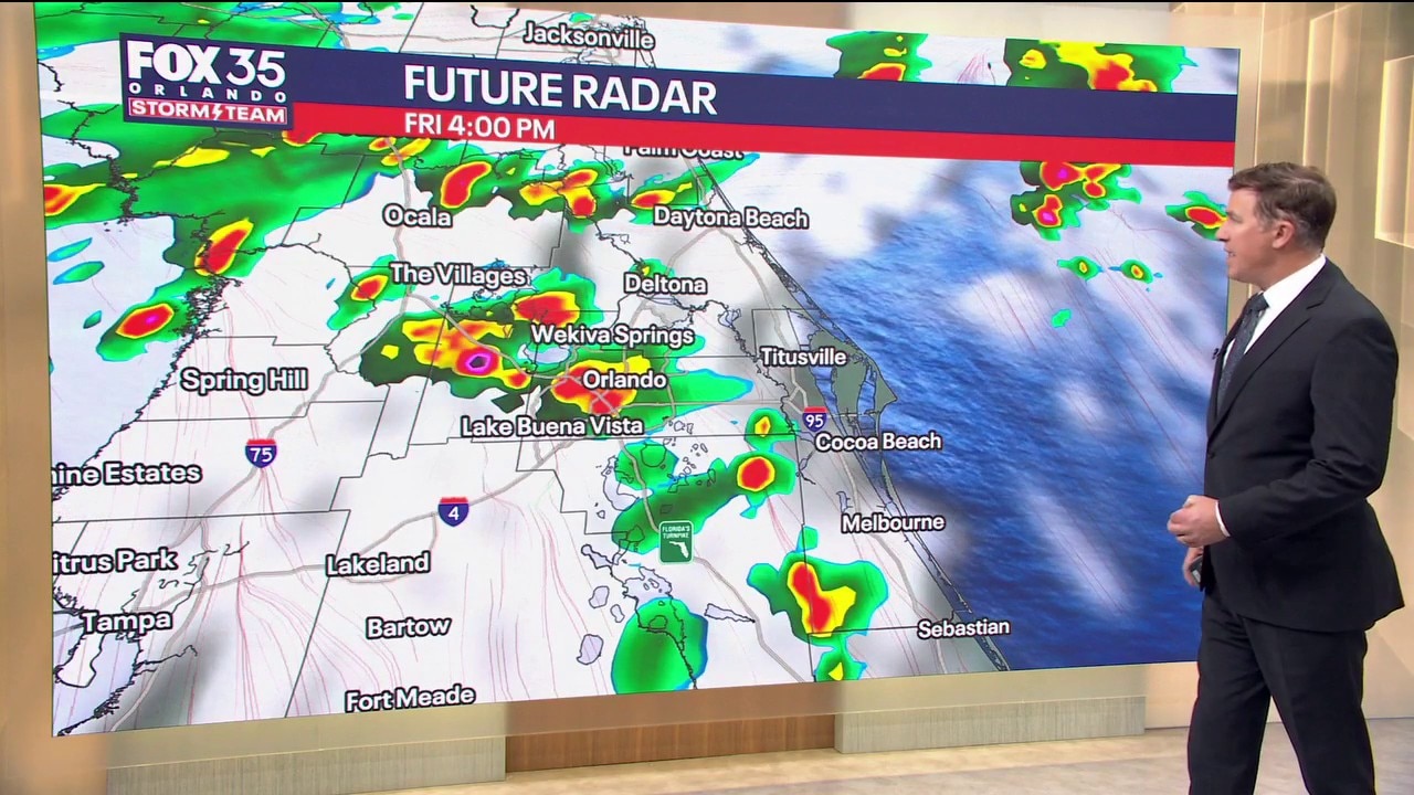
Orlando AM Weather Forecast: Rain continues in Central Florida
Scattered showers and thunderstorms are expected for Central Florida on Friday. The weekend is also expected to be a rainy one. FOX 35 Storm Team meteorologist Brooks Garner is tracking the downpours.
ORLANDO, Fla. - Central Florida will have a steamy Friday with sunshine at times, sending highs to near 90°F, as an approaching Hurricane Isaias makes landfall tonight in the western Panhandle.
Rain chances are 50-70%, with scattered showers and thunderstorms developing primarily during the afternoon and early evening.
A few stronger storms could produce wind gusts of 40-50 mph.
Storms should move faster today, limiting the widespread flooding threat. However, localized flooding remains possible where repeated downpours affect already saturated neighborhoods.
Stormy and breezy weekend ahead
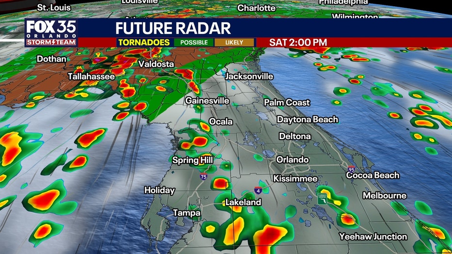
Our direct connection to deep Caribbean moisture continues Saturday and Sunday, with southerly winds feeding another round of afternoon and evening thunderstorms into Central Florida.
Feeder bands flowing into Isaias will move over our region Sunday, making for a slightly higher chance of rain for the second-half of the weekend.
Saturday will become breezy, with southeast winds increasing to 15-20 knots over nearby Atlantic waters. This'll make for rough beach conditions on the Atlantic side with a high risk for life-threatening rip currents.
Temperatures remain unusually warm and humid, with highs in the upper 80s and lower 90s and heat indices approaching 100-105°.
Rain chances remain elevated at 60-70% both days, with scattered storms Saturday and numerous thunderstorms developing during the afternoon Sunday.
A few stronger storms could produce wind gusts of 40-50 mph, occasional lightning and locally heavy rainfall. Additional flooding remains possible in communities where the ground is already saturated. An isolated tornado is possible on the Big Bend on the western side of our FOX 51 WOGX viewing area.
Drier weather arrives Monday
The pattern finally changes as a weak front moves through Central Florida on Monday, bringing noticeably drier air into the region behind Isaias.
Dew points could fall into the 60s as early as Monday afternoon, ending our prolonged stretch of oppressive tropical humidity.
Tuesday and Wednesday look mostly dry, with substantially lower rain chances, more sunshine and overnight lows falling into the mid 60s to lower 70s.
Afternoon temperatures will still climb well into the 80s, potentially approaching 90°, but the lower humidity should make conditions noticeably more comfortable.
Some moisture may return late next week, although nothing approaching the tropical moisture we've experienced recently.
Tracking the tropics: Hurricane Isaias now powerful Category 2 storm
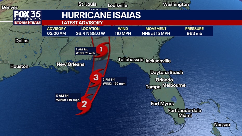
Hurricane Isaias intensified significantly overnight, with Hurricane Hunter aircraft finding a better-defined eye, a shrinking eyewall. Max sustained winds at 5am of 110mph. (Just 1 mph off from Category 3 "major hurricane" classification.)
The hurricane is becoming more symmetric and better organized on satellite imagery, suggesting additional strengthening is likely.
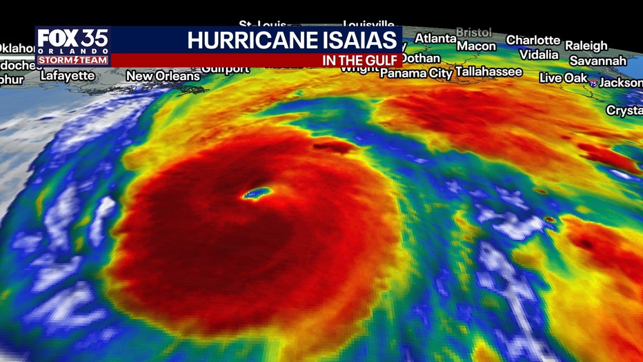
The National Hurricane Center now forecasts Isaias to reach 120 mph later this morning, making it a Category 3 major hurricane.
Very warm, deep Gulf waters remain favorable for intensification over the next 12 hours. However, a substantial increase in upper-level wind shear is expected before landfall, likely weakening the hurricane somewhat.
NHC currently forecasts a high-end Category 2 hurricane at landfall, but warns that a delay of just six hours in the arrival of stronger wind shear could allow a substantially stronger hurricane to reach the coast.
Regardless of its exact intensity at landfall, Isaias will remain extremely dangerous. Its wind field is expected to expand as the hurricane interacts with an approaching upper-level trough, spreading damaging winds and storm surge well away from the center.
Storm surge could extend as far east as Tampa Bay with 1-2 feet higher than normal waters and on the Big Bend from Cedar Key to Horseshoe beach, 2-4 feet of storm surge. There could be more than 7 feet of storm surge from Panama City Beach to Mobile Bay, Alabama.
When will it make landfall?:
Isaias is moving north-northeast at approximately 15 mph and is expected to turn more northerly and accelerate later today.
The latest NHC forecast brings the center ashore along the northern Gulf Coast tonight or early Saturday, near the Pensacola-Mobile area.
The greatest hurricane wind threat remains across southern Mississippi, southern Alabama and the western Florida Panhandle, where Hurricane Warnings are in effect.
Life-threatening storm surge is expected along a large portion of the northern and eastern Gulf Coast, from the mouth of the Mississippi River eastward toward Florida's Big Bend.
Significant storm surge, hurricane-force winds, widespread power outages and flooding rainfall are expected near and east of landfall.
The eastern side of Isaias will also need to be watched for tropical tornadoes tonight into Saturday.
One interesting forecast detail: NHC notes that the Google DeepMind AI model has out-performed the traditional models, and the latest official track remains very close to Deep Mind's guidance. This is pretty revolutionary for hurricane forecasting.
Damaging winds spread inland:
Isaias will quickly accelerate inland after landfall and begin transitioning into a powerful post-tropical system as it interacts with an upper-level trough.
The expanding wind field could bring damaging gusts well inland across central and northern Alabama, extreme eastern Mississippi and western and northern Georgia.
Higher elevations may be especially vulnerable to strong winds, with additional Tropical Storm and High Wind Watches or Warnings possible later today.
Heavy rainfall will also spread across much of the Southeast through the weekend, bringing the potential for significant flash flooding, urban flooding and river flooding.
By Sunday, the weakening post-tropical circulation is expected to move northeastward, with dissipation forecast by early Monday.
Central Florida impacts?:
Despite Isaias becoming a major hurricane today, the greatest direct hurricane impacts remain well northwest of Central Florida.
Our main concerns continue to be scattered to numerous afternoon thunderstorms, occasional strong wind gusts and localized flooding through Sunday.
The hurricane's influence will help lift our stalled frontal boundary northward while maintaining a deep connection to tropical moisture across the peninsula.
The good news: Isaias will help set the stage for a pattern change early next week, with a weak front arriving Monday and substantially drier air finally returning to Central Florida. It'll feel like fall again.
The Source: The information in this story was provided by the FOX 35 Storm Team.