Orlando weather forecast: Central Florida will see high chance of evening storms on Wednesday

Weather Forecast: August 16, 2022
Orlando and Central Florida will see a mostly dry Tuesday evening, but rain chances pick up on Wednesday.
ORLANDO, Fla. - WHAT IS THE WEATHER FORECAST FOR TODAY AROUND ORLANDO?
Tonight’s low: 77 degrees
Tomorrow's high: 94 degrees
Rain: 60% chance of p.m. storms
MAIN WEATHER CONCERNS:
Storms with torrential rain will be popping up after lunch on Wednesday with frequent lightning and gusty winds over 50 mph. The highest chance for storms in the Orlando metro will be 5 p.m. to 7 p.m. Storms will track southeastward and have no trouble reaching the beaches and potentially severe thunderstorm status, with damaging winds being the biggest threat. Otherwise, the westerly flow brings high humidity, ("swamp flow"), all week.
WHAT IS THE WEATHER FORECAST FOR WALT DISNEY WORLD, UNIVERSAL, AND SEAWORLD?
Another muggy day with scattered storms through the afternoon hours. Rain could be very heavy at times so watch that radar! Highs will climb to the mid-90s so make sure you stay hydrated.
WHAT IS THE WEATHER FORECAST FOR THE BEACHES IN CENTRAL FLORIDA?
More near record high temperatures at the beaches... 90s ahead with strong sun and an off-shore flow. There will be a 60% chance for afternoon storms at the beaches. Waves 1-2 feet, Winds westerly in the morning, shifting to a sea breeze southeast, onshore wind at 15mph. Slight risk for rip currents.
LOOKING AHEAD:
Remaining very muggy and becoming increasingly stormier. Fewer storms will develop over the weekend as drier air arrives. Depend on the FOX 35 Storm Team and download the FOX 35 Storm Team App!
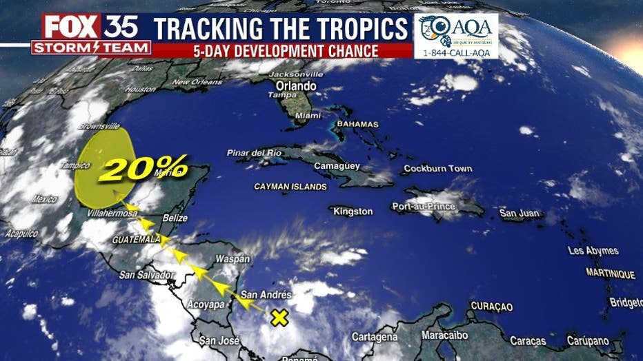
TROPICS:
A tropical wave in the southern Caribbean Sea is expected to drift northwest, toward the Bay of Campeche and could become a tropical depression or tropical storm in that region of the southwest Gulf of Mexico by Friday or Saturday. No threats to Florida as the circulation would likely drift into Mexico or Texas.